|
| Mesoscale Discussion 1679 |
|
< Previous MD Next MD >
|
|
Mesoscale Discussion 1679
NWS Storm Prediction Center Norman OK
1020 PM CDT Wed Sep 01 2021
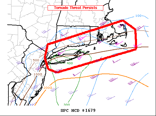
Areas affected...far northern New Jersey...southern New York...Long
Island...and far southern New England
Concerning...Tornado Watch 484...
Valid 020320Z - 020445Z
The severe weather threat for Tornado Watch 484 continues.
SUMMARY...Thunderstorms currently moving across Long Island and
southern New England will continue to pose a risk of strong
thunderstorm winds and a couple of tornadoes. A new watch downstream
of Tornado Watch #484 will be issued.
DISCUSSION...The remnant low-level circulation of post-tropical
cyclone Ida continues to move northeast toward the greater New York
City area. The low-level wind field continues to advect a very warm,
moist air northward into southern New England as a warm front slowly
lifts north across Long Island. Time-evolution VAD winds from Upton,
NY, (KOKX) suggests that the warm front is very near or just north
of the radar. Additionally, the time evolution of KOKX's VAD winds
indicates a strengthening wind field that veers with height, leading
to 0-1 kilometer SRH in excess of 800 m2/s2.
As thunderstorms continue to move east from northern New
Jersey/southern New York, across Long Island and southern New
England, they will interact with this extremely favorable kinematic
environment. The result is a continued potential for a couple of
tornadoes and strong thunderstorm winds along and south of the warm
front. The most appreciable tornado risk will be in the vicinity of
this lifting warm front, but how far north it lifts before being
overtaken by the approaching thunderstorms is uncertain. Portions o
coastal and near-coastal areas downstream from Tornado Watch #484
across southern New England will need a new tornado watch.
..Marsh.. 09/02/2021
...Please see www.spc.noaa.gov for graphic product...
ATTN...WFO...BOX...OKX...ALY...
LAT...LON 41317391 42217009 41846950 41126950 40277345 40407386
40837405 41317391
|
|
Top/All Mesoscale Discussions/Forecast Products/Home
|
|


 @NWSSPC