|
| Mesoscale Discussion 1648 |
|
< Previous MD Next MD >
|
|
Mesoscale Discussion 1648
NWS Storm Prediction Center Norman OK
1202 PM CDT Mon Aug 30 2021
Areas affected...northern/eastern Mississippi into western Alabama
Concerning...Severe potential...Watch unlikely
Valid 301702Z - 301930Z
Probability of Watch Issuance...20 percent
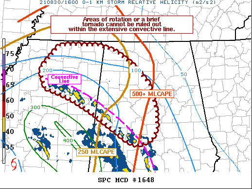
SUMMARY...A few strong storms are possible within an outer
convective band from northern Mississippi into western/central
Alabama, but potential currently appears too low for a watch.
Embedded areas of rotation or a brief/weak tornado cannot be ruled
out.
DISCUSSION...Several shallow convective elements are noted on radar
from northwest of Columbus MS to near Centreville AL, with stronger
storms continuing southward into tornado watch 475.
Objective analysis shows the more favorable instability into central
AL where MLCAPE is near 500 J/kg, while values are only near 250
J/kg along the MS/AL border. Low-level shear is currently maximized
over central and eastern MS, with 0-1 km SRH over 300 m2/s2.
Meanwhile, these shear values drop to around 150 m2/s2 over central
AL.
There may be a region of shear/instability overlap from northeast MS
into western AL this afternoon which could support increasing
rotation within the convective line. At this time, the threat is low
for tornadoes, but storm trends will continue to be monitored for
increasing rotation potential.
..Jewell/Grams.. 08/30/2021
...Please see www.spc.noaa.gov for graphic product...
ATTN...WFO...BMX...HUN...MEG...JAN...
LAT...LON 33378662 32988661 32728675 32618706 32628726 32758751
33308832 33628889 33788934 33878971 34328988 34898935
34908825 34778775 34438722 33998680 33378662
|
|
Top/All Mesoscale Discussions/Forecast Products/Home
|
|


 @NWSSPC