|
| Mesoscale Discussion 1610 |
|
< Previous MD Next MD >
|
|
Mesoscale Discussion 1610
NWS Storm Prediction Center Norman OK
0120 PM CDT Thu Aug 26 2021
Areas affected...Northwestern Maine
Concerning...Severe potential...Watch unlikely
Valid 261820Z - 261945Z
Probability of Watch Issuance...20 percent
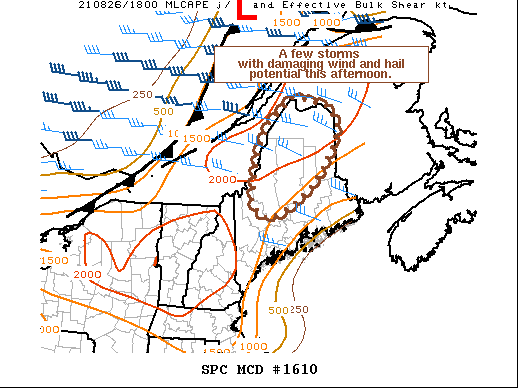
SUMMARY...Thunderstorms developing ahead of a cold front across
eastern Quebec will move eastward with a risk for isolated damaging
winds and hail this afternoon. Uncertainty on storm coverage remains
considerable at this time. Convective trends will be monitored but a
watch is unlikely.
DISCUSSION...As of 18 UTC, regional surface observations and visible
satellite data showed deepening cumulus along a fast moving cold
front in the vicinity of Quebec City, QC. Downstream across portions
of northern/western ME, daytime heating of a moist airmass with
dewpoints near 70 f is supporting moderate destabilization. SPC
mesoanalysis indicates 1500-2500 J/kg of MLCAPE has developed with
additional destabilization likely in the coming hours. Increasing
westerly flow aloft ahead of shortwave trough within interior Canada
is forecast to overspread the unstable airmass through this evening
with 35-45 kt of effective shear.
RAP forecast soundings show long but only weakly veering hodographs
supportive of a mixed-mode of splitting supercells and line segments
capable of damaging wind gusts and severe hail. Mesoscale trends and
hi-res guidance suggest convective development along the front is
likely over the next several hours though it is uncertain exactly
how much storm coverage will develop. As storms track eastward
across the international border additional development and some
upscale growth into several clusters or line segments with a risk
for damaging winds/hail appears possible but remains uncertain. The
threat for isolated wind gusts and hail may extend eastward with
time across much of central ME until storms begin to interact with a
cooler and more stable maritime airmass near the Atlantic coast.
..Lyons/Dial.. 08/26/2021
...Please see www.spc.noaa.gov for graphic product...
ATTN...WFO...CAR...GYX...
LAT...LON 45197049 46287032 46946990 47496919 47436875 47306803
46946772 46436784 45936820 45526858 45176902 45036930
44786983 44807012 44977034 45197049
|
|
Top/All Mesoscale Discussions/Forecast Products/Home
|
|


 @NWSSPC