|
| Mesoscale Discussion 1592 |
|
< Previous MD Next MD >
|
|
Mesoscale Discussion 1592
NWS Storm Prediction Center Norman OK
1244 PM CDT Tue Aug 24 2021
Areas affected...northeast Iowa...extreme southeast Minnesota and
southwest Wisconsin
Concerning...Severe potential...Watch possible
Valid 241744Z - 241915Z
Probability of Watch Issuance...40 percent
SUMMARY...Threat for damaging wind may undergo an increase across
northeast Iowa, southeast Minnesota into southwest Wisconsin this
afternoon. Overall scenario is not particularly high confidence, but
trends are being monitored for a possible severe thunderstorm watch.
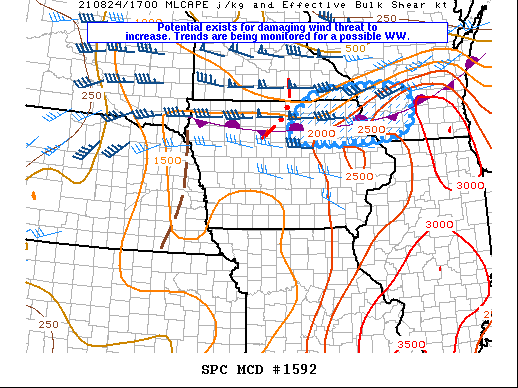
DISCUSSION...As of early afternoon a line of storms has recently
undergone some intensification along the southern MN / northern IA
border. These storms are developing on the cool side of an east-west
oriented convective outflow boundary. South of this boundary the
atmosphere is destabilizing with MLCAPE from 2000-2500 J/kg
supported by strong diabatic heating of the moist surface layer.
Theta-e advection from the unstable warm sector may contribute to
further intensification of storms north of the boundary. It also
appears that an MCV or meso-gamma-scale circulation is evident along
the northern end of the line which might help to sustain an
organized linear MCS next few hours despite tendency for slight
warming aloft.
..Dial/Kerr.. 08/24/2021
...Please see www.spc.noaa.gov for graphic product...
ATTN...WFO...MKX...DVN...ARX...DMX...
LAT...LON 43539274 43769148 43728986 43178960 42698997 42549171
42669328 43539274
|
|
Top/All Mesoscale Discussions/Forecast Products/Home
|
|


 @NWSSPC