|
| Mesoscale Discussion 1577 |
|
< Previous MD Next MD >
|
|
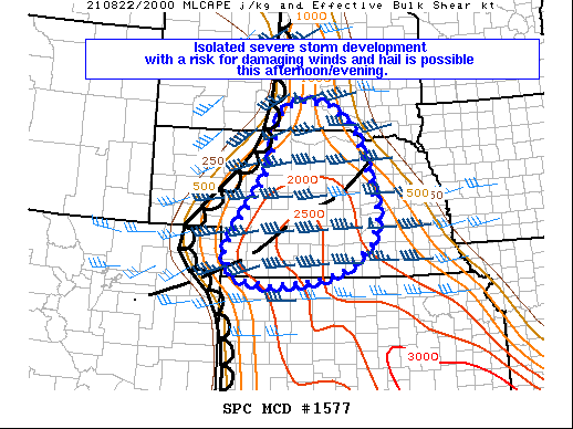
   Mesoscale Discussion 1577
   NWS Storm Prediction Center Norman OK
   0338 PM CDT Sun Aug 22 2021

   Areas affected...central NE into far southern SD and extreme
   northern KS

   Concerning...Severe potential...Watch possible

   Valid 222038Z - 222215Z

   Probability of Watch Issuance...40 percent

   SUMMARY...A damaging wind and hail risk may develop if thunderstorms
   are able to organize late this afternoon and into this evening. A
   weather watch is possible but uncertainty on the nature of any
   severe threat remains high.

   DISCUSSION...As of 2015 UTC, visible satellite imagery showed
   towering cumulus deepening east of a lee trough/dryline and along a
   diffuse differential heating axis through central Nebraska. On the
   southern fringes of a compact upper low across the western Dakotas,
   large-scale synoptic lift will continue to overspread a rapidly
   warming airmass this afternoon. With additional heating and surface
   dewpoints climbing into the 60s and 70s F, regional RAP soundings
   develop 2000-3000 J/kg of MLCAPE by late this afternoon. Moderate
   deep-layer shear will be augmented by stronger flow aloft ahead of
   the approaching upper low. SPC mesoanalysis shows 40-50 kt of
   effective shear co-located with favorable buoyancy across much of
   Nebraska and northern Kansas.

   Satellite trends and recent CAM guidance suggests storm development
   along the dryline and differential heating axis is possible by
   22-23z. Storm coverage is uncertain as forcing for ascent will be
   quite subtle from the glancing of the upper low. However, given the
   favorable thermodynamic and kinematic variables at play, any storms
   that do develop will likely become supercells with the potential for
   damaging wind gusts and large hail. CAM guidance suggests additional
   storm development may also support upscale growth later in the
   evening across east-central Nebraska. Convective trends will be
   monitored for a possible weather watch, but storm coverage and the
   resulting severe threat remains uncertain.

   ..Lyons/Kerr.. 08/22/2021

   ...Please see www.spc.noaa.gov for graphic product...

   ATTN...WFO...FSD...OAX...ABR...GID...LBF...UNR...GLD...

   LAT...LON   41169785 40689802 40309851 40119883 39929967 39840070
               39920138 40060171 40480195 40850174 41740108 42360070
               42950060 43170053 43380044 43480030 43609975 43489909
               42949839 42509822 42109807 41509787 41169785
|
|
Top/All Mesoscale Discussions/Forecast Products/Home
|
|


 @NWSSPC