|
| Mesoscale Discussion 1523 |
|
< Previous MD Next MD >
|
|
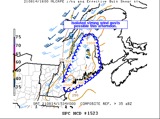
   Mesoscale Discussion 1523
   NWS Storm Prediction Center Norman OK
   1124 AM CDT Sat Aug 14 2021

   Areas affected...central and eastern ME

   Concerning...Severe potential...Watch unlikely

   Valid 141624Z - 141800Z

   Probability of Watch Issuance...20 percent

   SUMMARY...Isolated strong thunderstorms could produce strong,
   locally damaging wind gusts this afternoon.

   DISCUSSION...Thunderstorms are increasing in coverage and intensity
   in the vicinity of a surface cold front across western ME. Morning
   convection that moved across the state has limited heating over
   portions of the region, but some airmass recovery is underway.
   Dewpoints in the upper 60s to near 70 F beneath moderate midlevel
   flow will support isolated strong convection through the afternoon
   as the cold front progresses east/southeast across New England.
   Pockets of 1000-1500 J/kg MLCAPE and steepening low level lapse
   rates, along with PW values approaching 2 inches, will support
   semi-organized cells/clusters capable of sporadic strong, to locally
   damaging gusts. Marginal effective shear magnitudes and a lack of
   stronger instability with poor midlevel lapse rates should limit a
   more organized and intense threat, and a watch is not expected at
   this time.

   ..Leitman/Hart.. 08/14/2021

   ...Please see www.spc.noaa.gov for graphic product...

   ATTN...WFO...CAR...GYX...

   LAT...LON   47166889 47366826 47236802 46966768 46046751 45426738
               44836738 44456772 43536955 43197064 43577100 43967088
               44617054 45816985 46226956 47166889
|
|
Top/All Mesoscale Discussions/Forecast Products/Home
|
|


 @NWSSPC