|
| Mesoscale Discussion 1430 |
|
< Previous MD Next MD >
|
|
Mesoscale Discussion 1430
NWS Storm Prediction Center Norman OK
1103 AM CDT Sat Aug 07 2021
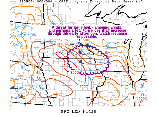
Areas affected...Portions of southeastern MN...northeastern IA...and
western WI
Concerning...Severe potential...Watch possible
Valid 071603Z - 071830Z
Probability of Watch Issuance...40 percent
SUMMARY...A threat for large hail, damaging wind gusts, and perhaps
a few tornadoes may increase through the early afternoon. Watch
issuance is possible.
DISCUSSION...Recent visible satellite and radar imagery clearly
shows a MCV moving quickly eastward across MN and towards
west-central WI late this morning. On the southern flank of this
feature, a 25-35 kt southwesterly low-level jet has encouraged a
recent uptick in convection across southeastern MN and northeastern
IA. It appears that this activity is mainly elevated at the moment,
with a weak front/outflow boundary located over southern MN. Still,
with around 35-40 kt of deep-layer shear present, any elevated
supercells may pose an isolated threat for primarily large hail in
the short term. Storms may eventually transition to surface-based
over the next few hours, particularly along and south of the
convectively reinforced boundary over southern MN.
A rich low-level airmass characterized by at least low 70s surface
dewpoints is present across much of IA into southern MN. Both
diurnal heating of this airmass and the presence of steep mid-level
lapse will likely contribute to around 2000-3000 J/kg of MLCAPE this
afternoon. In addition to the large hail threat with any supercells,
damaging winds may also occur if storms can congeal into one or more
clusters and then move east-southeastward along the surface boundary
into western WI. 25-35 kt of southwesterly winds in the boundary
layer and a veering wind profile with height should support 100-200
m2/s2 of 0-1 km SRH, sufficient for updraft rotation and a threat
for a few tornadoes. This tornado threat will probably be maximized
near the surface boundary across parts of southern MN into far
northeastern IA and southwestern WI. Convective trends will be
closely monitored for possible watch issuance in the next few hours.
..Gleason/Thompson.. 08/07/2021
...Please see www.spc.noaa.gov for graphic product...
ATTN...WFO...MKX...DVN...ARX...MPX...DMX...
LAT...LON 43548995 42998986 42689018 42539067 42409221 42669321
42949368 43929391 44389282 44439206 44209109 43548995
|
|
Top/All Mesoscale Discussions/Forecast Products/Home
|
|


 @NWSSPC