|
| Mesoscale Discussion 1396 |
|
< Previous MD Next MD >
|
|
Mesoscale Discussion 1396
NWS Storm Prediction Center Norman OK
0324 PM CDT Fri Jul 30 2021
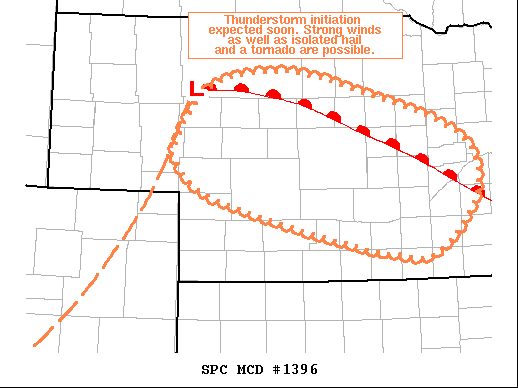
Areas affected...Central NE
Concerning...Severe potential...Watch likely
Valid 302024Z - 302230Z
Probability of Watch Issuance...80 percent
SUMMARY...Thunderstorms are expected to develop within the next hour
or so. Strong wind gusts should be the primary threat with any
storms but isolated hail and a tornado or two are also possible.
Given these threats, a watch will likely be needed by 21Z.
DISCUSSION...Recent surface analysis places a low about 40 miles
west of MHN in northwest NE. A warm front extends southeastward from
this low across central and southeast NE. Limited mixing in the
vicinity of this front amid persistent low-level moisture advection
has contributed to swath of 70-75 deg F dewpoints across central NE.
Surface temperatures have recently climbed into the upper 80s/low
80s, effectively eroding convective inhibition while also contribute
to strong buoyancy. Visible satellite imagery has some deeper
cumulus near the surface low and the current prediction is for
eventual convective initiation in this area.
Much of this region is on the southern edge of the better flow
aloft, and the expectation is for initial development to be
outflow-dominant. The overall thermodynamic profile appears very
favorable for strong downdrafts. As such, strong wind gusts appear
to be the primary threat. That being said, the strength of the
buoyancy could still lead to isolated hail production. As the storm
move eastward, and more southeasterly/easterly component to the
surface will should contribute to an increase in low-level vertical
shear. Additionally, strong vertical vorticity is in place near the
warm front. These factors will contribute to the potential for a
tornado or two. Given these anticipated threats and expectation for
storm initiation within the hour, a watch will likely be needed by
21Z.
..Mosier/Grams.. 07/30/2021
...Please see www.spc.noaa.gov for graphic product...
ATTN...WFO...OAX...GID...LBF...
LAT...LON 42020181 42300133 42370031 42129921 41809816 41429760
40879761 40299820 40299880 40419945 40750088 41040176
41350208 41500212 42020181
|
|
Top/All Mesoscale Discussions/Forecast Products/Home
|
|


 @NWSSPC