|
| Mesoscale Discussion 1346 |
|
< Previous MD Next MD >
|
|
Mesoscale Discussion 1346
NWS Storm Prediction Center Norman OK
0457 PM CDT Sun Jul 25 2021
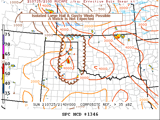
Areas affected...Oklahoma and Texas Panhandles...far western
Oklahoma...and extreme northwest Texas
Concerning...Severe potential...Watch unlikely
Valid 252157Z - 252330Z
Probability of Watch Issuance...5 percent
SUMMARY...Thunderstorms will continue across the area this
afternoon. Extreme instability will support brief potential for
severe hail and wind with the strongest thunderstorm updrafts. Weak
shear should limit the overall severe threat. A watch is not
expected.
DISCUSSION...Showers and thunderstorms continue to develop within a
band of low-level convergence associated with the lee trough.
Extreme instability, most-unstable CAPE in excess of 3500 J/kg, may
support brief, isolated large hail and gusty thunderstorm outflows
with the strongest updraft pulses. However, weak effective-layer
shear -- between 10-15 knots -- will limit overall thunderstorm
organization to storm-scale processes. Thunderstorm intensity should
wane later this evening with the loss of diurnal heating. The
overall disorganized nature of the threat should preclude the need
of a watch.
..Marsh/Grams.. 07/25/2021
...Please see www.spc.noaa.gov for graphic product...
ATTN...WFO...OUN...LUB...AMA...
LAT...LON 36800127 36950094 36959975 36709946 35609948 34659950
34109971 33510045 33850150 34990158 36190138 36800127
|
|
Top/All Mesoscale Discussions/Forecast Products/Home
|
|


 @NWSSPC