|
| Mesoscale Discussion 1287 |
|
< Previous MD Next MD >
|
|
Mesoscale Discussion 1287
NWS Storm Prediction Center Norman OK
0542 PM CDT Wed Jul 14 2021
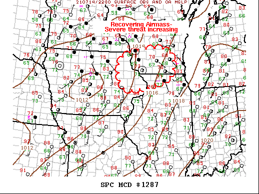
Areas affected...Eastern IA...Northern IL...Southern WI
Concerning...Severe potential...Watch likely
Valid 142242Z - 142345Z
Probability of Watch Issuance...80 percent
SUMMARY...Severe threat is increasing across eastern IA/northwestern
IL into southern WI. New ww will likely be warranted soon.
DISCUSSION...Early-day MCS has progressed across the upper Midwest
with the leading edge now spreading across LE. Considerable
boundary-layer disruption has been noted across WI/northern IL into
extreme northeast IA. However, over the last few hours, partial
clearing across eastern IA has allowed surface temperatures to warm
into the lower 80s from east of ALO-MXO-CWI-north of C75 in
Illinois. Further recover appears likely to near the WI/IL border
over the next few hours. While updrafts may struggle to be truly
surface-based where temperatures struggle to rise above 75F, there
is increasing concern/confidence that ongoing supercells over
central IA will progress east of ww378 into a region that is
recovering in the wake of earlier convection. Ample shear/buoyancy
suggest supercells will continue, along with a tornado threat.
Additionally, LLJ is forecast to increase across southern/central WI
this evening and this should encourage renewed convective
development. New ww will likely be issued soon.
..Darrow/Guyer.. 07/14/2021
...Please see www.spc.noaa.gov for graphic product...
ATTN...WFO...LOT...MKX...DVN...ARX...
LAT...LON 43269164 43638913 42848852 42168919 41829151 43269164
|
|
Top/All Mesoscale Discussions/Forecast Products/Home
|
|


 @NWSSPC