|
| Mesoscale Discussion 1248 |
|
< Previous MD Next MD >
|
|
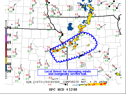
   Mesoscale Discussion 1248
   NWS Storm Prediction Center Norman OK
   0739 PM CDT Sat Jul 10 2021

   Areas affected...Parts of northeast Kansas and west-central Missouri

   Concerning...Severe Thunderstorm Watch 366...

   Valid 110039Z - 110145Z

   The severe weather threat for Severe Thunderstorm Watch 366
   continues.

   SUMMARY...Threat for strong/severe wind gusts is becoming more
   localized in WW 366. Greatest potential exists along southwest flank
   of convection now near Lawrence, KS.

   DISCUSSION...The line of storms moving along the Missouri River has
   become somewhat less organized over the past 90 minutes. Convection
   forming ahead of the line has generally remained weak and has left
   outflow from roughly near Lawrence, KS into the eastern Kansas City
   Metro area. This outflow along with a greater influence of
   convection farther to the south is expected to limit the overall
   intensity of storms as the evening progresses. Storms on the
   southwestern flank of of the activity have the greatest potential
   for strong/severe wind gusts, with Lawrence, KS gusting to 60 kts
   recently. However, KEAX radar imagery shows outflow quickly moving
   ahead of these storms making the threat potentially short-lived.

   ..Wendt.. 07/11/2021

   ...Please see www.spc.noaa.gov for graphic product...

   ATTN...WFO...EAX...TOP...

   LAT...LON   39019561 39309484 39609425 39849367 39719322 39409287
               39159294 38839371 38609466 38519510 38569526 39019561
|
|
Top/All Mesoscale Discussions/Forecast Products/Home
|
|


 @NWSSPC