|
| Mesoscale Discussion 1234 |
|
< Previous MD Next MD >
|
|
Mesoscale Discussion 1234
NWS Storm Prediction Center Norman OK
0309 AM CDT Sat Jul 10 2021
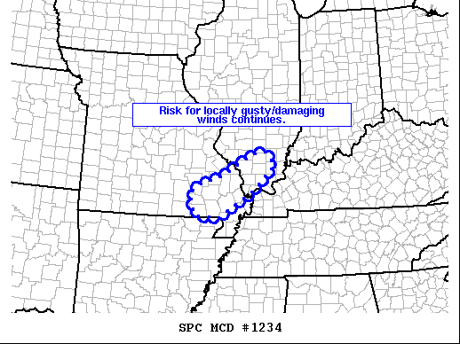
Areas affected...southeastern Missouri/southern Illinois
Concerning...Severe Thunderstorm Watch 364...
Valid 100809Z - 101015Z
The severe weather threat for Severe Thunderstorm Watch 364
continues.
SUMMARY...Local risk for gusty/damaging winds continues across WW
364.
DISCUSSION...Latest radar loop shows near-continuous line of strong
storms moving southeastward across southeastern Missouri and
adjacent southern Illinois at around 30 kt. Ahead of the storms, an
airmass featuring 1000 to 1500 J/kg mixed-layer CAPE persists, which
should allow convection to persist as it advances steadily
southeastward. While the latest PAH WSR-88D VWP data shows only
moderate (AOB 30 kt) flow through the lower half of the troposphere,
a few stronger gusts remain possible given the still-organized
nature of the convective band.
..Goss.. 07/10/2021
...Please see www.spc.noaa.gov for graphic product...
ATTN...WFO...PAH...MEG...LSX...SGF...
LAT...LON 37329078 37559010 38118912 38168874 37828843 37128915
36499019 36519095 37099113 37329078
|
|
Top/All Mesoscale Discussions/Forecast Products/Home
|
|


 @NWSSPC