|
| Mesoscale Discussion 1199 |
|
< Previous MD Next MD >
|
|
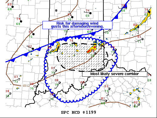
   Mesoscale Discussion 1199
   NWS Storm Prediction Center Norman OK
   1251 PM CDT Thu Jul 08 2021

   Areas affected...portions of the Ohio River Valley and central
   Indiana.

   Concerning...Severe potential...Watch possible

   Valid 081751Z - 081915Z

   Probability of Watch Issuance...40 percent

   SUMMARY...Several clusters of strong thunderstorms will pose a risk
   mainly for damaging wind gusts as they track southeastward this
   afternoon. Convective trends are being monitored for a possible
   weather watch.

   DISCUSSION...Over the last hour, regional radar mosaics and visible
   imagery have shown thunderstorms increasing in intensity and
   coverage across portions of south-central Indiana and eastern
   Illinois. Located along a cold front front beneath the western
   portions of a mid-level trough, these storms are ongoing in a
   moderately unstable/sheared environment. Obs and SPC mesoanalysis
   indicate dewpoints in the 70s F are contributing to around 1500-2000
   J/kg of MLCAPE despite modest mid-level lapse rates. Mid-level flow
   behind the trough is not overly strong, but is supporting 25-30 kts
   of effective shear. This should act to organize storms into
   multicell clusters and short line segments capable of damaging wind
   gusts.

   As additional storm development takes place this afternoon, some
   upscale growth into a more organized linear segment appears
   possible. As such, an additional risk for damaging winds may develop
   near and immediately south of the Ohio River across portions of
   northern Kentucky and southwestern Ohio. Uncertainty on the nature
   of the severe threat remains, but convective trends suggest a watch
   could be needed this afternoon.

   ..Lyons/Guyer.. 07/08/2021

   ...Please see www.spc.noaa.gov for graphic product...

   ATTN...WFO...ILN...LMK...IND...PAH...ILX...

   LAT...LON   39718473 39608450 39278426 39118424 38728457 38498471
               37998525 37628604 37578675 37818717 38268758 38658761
               39058762 39438751 39788715 39908655 39888561 39798508
               39718473
|
|
Top/All Mesoscale Discussions/Forecast Products/Home
|
|


 @NWSSPC