|
| Mesoscale Discussion 1188 |
|
< Previous MD Next MD >
|
|
Mesoscale Discussion 1188
NWS Storm Prediction Center Norman OK
0611 PM CDT Wed Jul 07 2021
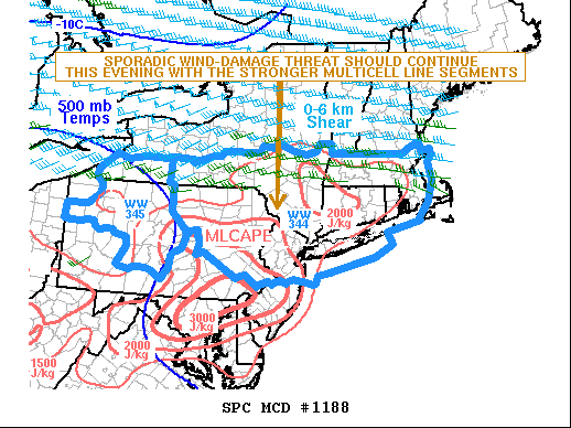
Areas affected...Northern Pennsylvania...Southern New
York...Southern New England
Concerning...Severe Thunderstorm Watch 344...345...
Valid 072311Z - 080115Z
The severe weather threat for Severe Thunderstorm Watch 344, 345
continues.
SUMMARY...A wind-damage threat will continue for several more hours
as cells track eastward across WW 344 and WW 345.
DISCUSSION...Surface analysis at 23Z shows a quasi-stationary front
located from near Lake Erie eastward across southern New York into
southern New England. To the south of the front, surface dewpoints
are in the upper 60s and lower 70s F. This is contributing to a
moderately unstable airmass, with the RAP estimating MLCAPE in the
1500 to 2000 J/kg range across the northern parts of WW 344 and 345.
In addition to the moist airmass, 0-6 km shear is measured near 35
kt on the Binghamton WSR-88D VWP. This appears representative of the
amount of shear across the northern part of the watches. The shear
combined with the instability will be sufficient for isolated
damaging wind gusts, associated with the more organized multicell
line segments. The threat should be greatest over the next couple
hours as low-level lapse rates remain steep. As the boundary layer
cools later this evening, the severe threat should become more
isolated.
..Broyles.. 07/07/2021
...Please see www.spc.noaa.gov for graphic product...
ATTN...WFO...BOX...OKX...ALY...PHI...BGM...BUF...CTP...PBZ...
LAT...LON 42647337 42607124 42387092 41947078 41377099 41067203
40787520 40867806 41647918 41987931 42307898 42487682
42627359 42647337
|
|
Top/All Mesoscale Discussions/Forecast Products/Home
|
|


 @NWSSPC