|
| Mesoscale Discussion 1166 |
|
< Previous MD Next MD >
|
|
Mesoscale Discussion 1166
NWS Storm Prediction Center Norman OK
0355 PM CDT Tue Jul 06 2021
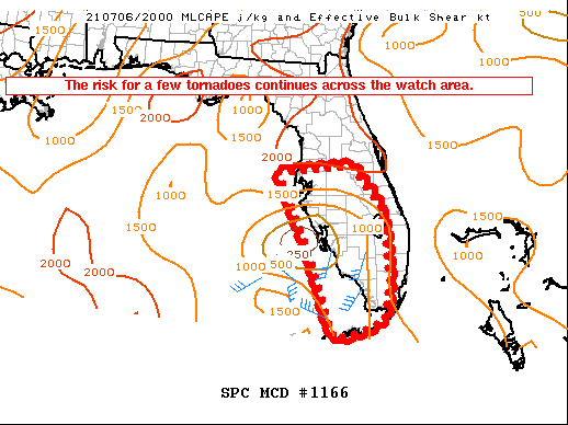
Areas affected...Southern/central Florida and the FL Keys
Concerning...Tornado Watch 337...
Valid 062055Z - 062230Z
The severe weather threat for Tornado Watch 337 continues.
SUMMARY...The threat for a few tornadoes continues across the watch
area through this evening.
DISCUSSION...Tropical Storm Elsa continues to move north at 10 mph
west of the Florida west coast, and was located 155 miles south
southwest of Tampa at 2045z (see the latest NHC advisory for
complete details). Low-level wind fields will strengthen slightly
over the next several hours as the system continues to slowly
intensify, and this will result in an increase in effective SRH
across portions of southern/central FL. Latest hi-res guidance
suggests an uptick in the intensity of outer bands across mainly
western portions of the watch area this evening, with a
corresponding increase in the risk for a few tornadoes.
..Bunting.. 07/06/2021
...Please see www.spc.noaa.gov for graphic product...
ATTN...WFO...MFL...MLB...KEY...TBW...
LAT...LON 28158323 28258139 27298069 25788056 24908072 24608149
24538191 26358246 28158323
|
|
Top/All Mesoscale Discussions/Forecast Products/Home
|
|


 @NWSSPC