Mesoscale Discussion 1137
NWS Storm Prediction Center Norman OK
0348 PM CDT Wed Jun 30 2021
Areas affected...Portions of far northeastern PA into
central/southern NY...MA...and northern CT
Concerning...Severe Thunderstorm Watch 326...329...
Valid 302048Z - 302215Z
The severe weather threat for Severe Thunderstorm Watch 326, 329
continues.
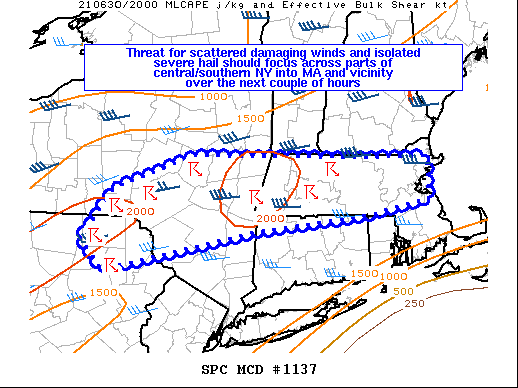
SUMMARY...The threat for scattered damaging winds and isolated
severe hail should focus across parts of central/southern New York
into Massachusetts and vicinity over the next couple of hours.
DISCUSSION...Two loosely organized clusters of storms are present
this afternoon, one over far northeastern PA into central NY, and
the other over western into central MA. Strong boundary-layer
heating has occurred ahead of these storms, and rather steep
low-level lapse rates around 8-9 C/km have developed downstream.
This region remains on the southern fringe of the stronger mid-level
westerly flow. Still, recent VWPs from KBGM and KENX show modestly
strengthening westerly winds with height through mid levels, and
around 30-40 kt of deep-layer shear remain present. Multicell
clusters will likely continue to pose a threat for scattered
damaging wind gusts. Some marginally severe hail may also occur,
particularly with any embedded supercell within the cluster in
western/central MA. It appears the greatest overall severe threat
may focus across MA in the short term, where the best overlap of
steep low-level lapse rates, moderate instability, and sufficient
deep-layer shear overlap.
..Gleason.. 06/30/2021
...Please see www.spc.noaa.gov for graphic product...
ATTN...WFO...BOX...ALY...BGM...
LAT...LON 41737614 42327567 42717444 42717327 42687188 42687087
42197085 42027180 41857346 41387581 41737614
|


 @NWSSPC