|
| Mesoscale Discussion 1129 |
|
< Previous MD Next MD >
|
|
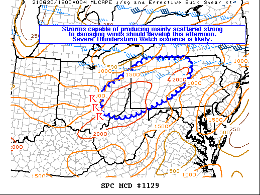
   Mesoscale Discussion 1129
   NWS Storm Prediction Center Norman OK
   1030 AM CDT Wed Jun 30 2021

   Areas affected...Portions of eastern OH...northern WV...and
   western/central PA

   Concerning...Severe potential...Severe Thunderstorm Watch likely

   Valid 301530Z - 301730Z

   Probability of Watch Issuance...80 percent

   SUMMARY...Storms capable of producing mainly scattered strong to
   damaging winds should develop this afternoon. Severe Thunderstorm
   Watch issuance is likely.

   DISCUSSION...Stronger mid-level flow associated with an upper trough
   over Ontario, Quebec, and the Great Lakes will mostly remain to the
   north of PA. Even so, modest enhancement to the mid-level
   southwesterlies should overlie parts of the upper OH Valley into
   western/central PA this afternoon. Around 25-35 kt of effective bulk
   shear is forecast to be present across the warm sector, which should
   support some storm organization. Multicell clusters should be the
   dominant storm mode given the marginally sufficient deep-layer
   shear. Continued diurnal heating of the rather moist low-level
   airmass ahead of morning storms in western/central OH will likely
   foster 1000-2000 J/kg of MLCAPE by mid afternoon from eastern OH
   into northern WV and much of western/central PA. Locally stronger
   instability may develop across parts of this region. Steepening
   low-level lapse rates should allow for efficient downdraft
   accelerations, and scattered damaging wind gusts will likely be the
   primary severe threat as storms spread eastward through the
   afternoon and early evening. A Severe Thunderstorm Watch will likely
   be needed in the next couple of hours as storms gradually increase
   in coverage and intensity.

   ..Gleason/Thompson.. 06/30/2021

   ...Please see www.spc.noaa.gov for graphic product...

   ATTN...WFO...CTP...PBZ...RLX...CLE...

   LAT...LON   39538209 39948213 40508212 40988124 41937958 41947831
               41927701 41437691 40877724 40227825 39847929 39428045
               39318129 39538209
|
|
Top/All Mesoscale Discussions/Forecast Products/Home
|
|


 @NWSSPC