|
| Mesoscale Discussion 1120 |
|
< Previous MD Next MD >
|
|
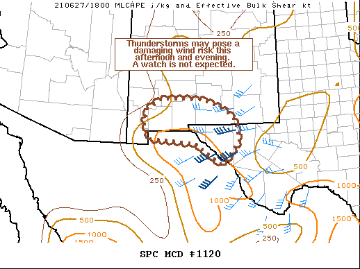
   Mesoscale Discussion 1120
   NWS Storm Prediction Center Norman OK
   0118 PM CDT Sun Jun 27 2021

   Areas affected...Southern New Mexico and far southwest Texas

   Concerning...Severe potential...Watch unlikely

   Valid 271818Z - 272015Z

   Probability of Watch Issuance...5 percent

   SUMMARY...Isolated to scattered thunderstorms may intensify and pose
   a damaging wind threat through the late afternoon and evening hours.
   The threat should be limited enough to preclude the need for a
   watch.

   DISCUSSION...Isolated to scattered thunderstorms have developed
   within the higher terrain of the Gila region of southwest NM over
   the past two hours, and are expected to propagate east/southeastward
   towards southern NM/southwest TX through the late afternoon.
   Additionally, cumulus along the TX/NM border has shown signs of
   gradual deepening, signifying waning inhibition. The combination of
   daytime heating and weak moisture advection has been gradually
   increasing MLCAPE through the late morning/early afternoon with
   roughly 500-1000 J/kg already in place over the region. Although
   flow aloft is modest, a nearly 180 degree wind shift above 2-3 km
   (noted in regional VWPs) is supporting close to 40 knots of
   effective bulk shear, which should aid in convective organization as
   discrete cells and clusters move towards the international border
   and/or develop out of the deepening cumulus field. Additionally,
   low-level lapse rates are steepening amid deeper boundary-layer
   mixing with 7-8 C/km 0-3 km lapse rates noted in recent mesoanalysis
   estimates. This may allow for strong outflows and an attendant
   damaging wind threat with any organized storm or cluster. However,
   the coverage of any strong to severe storms should remain somewhat
   limited given the marginal instability and narrow spatial overlap
   with favorable wind shear, and will likely preclude the need for a
   watch.

   ..Moore/Hart.. 06/27/2021

   ...Please see www.spc.noaa.gov for graphic product...

   ATTN...WFO...MAF...EPZ...

   LAT...LON   31520810 31960835 32470828 32850768 32830620 32700573
               32360510 32140482 31470468 30980504 30670532 31030587
               31390638 31500764 31520810
|
|
Top/All Mesoscale Discussions/Forecast Products/Home
|
|


 @NWSSPC