|
| Mesoscale Discussion 1110 |
|
< Previous MD Next MD >
|
|
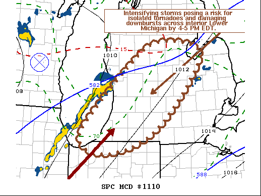
   Mesoscale Discussion 1110
   NWS Storm Prediction Center Norman OK
   1248 PM CDT Sat Jun 26 2021

   Areas affected...Parts of western through central lower Michigan

   Concerning...Tornado Watch 321...

   Valid 261748Z - 261845Z

   The severe weather threat for Tornado Watch 321 continues.

   SUMMARY...Intensifying thunderstorms posing a risk for isolated
   tornadoes and damaging downbursts are possible across interior
   central and southern Lower Michigan by 4-5 PM EDT.

   DISCUSSION...Slowly strengthening and upscale growing thunderstorm
   activity has organized into a line across southern lower Michigan.
   This will likely continue advecting within 30-40+ kt southwesterly
   deep-layer mean ambient flow across the Lake Michigan shoreline
   through much of southwestern and central Lower Michigan by 20-21Z.

   This appears supported by large-scale forcing for ascent to the east
   of a lower/mid-level low centered over Iowa, perhaps aided by a
   remnant MCV now crossing southeastern Wisconsin, and coincides with
   strengthening low-level and deep-layer vertical shear.  This
   includes a northeastward migrating south-southwesterly 850 mb jet,
   which may continue to strengthen to 40-50 kt as it propagates across
   southern Lower Michigan by late afternoon.

   Due to generally modest to weak lapse rates, boundary-layer CAPE is
   still weak, but will continue to gradually increase with additional
   insolation.  This is expected to be sufficient to support
   substantive further intensification of the approaching line as it
   moves onshore and inland.  Isolated discrete storm development may
   also occur ahead of the line, in an environment becoming
   increasingly conducive to strengthening low-level mesocyclones
   posing a risk for strong downbursts and perhaps a couple of
   tornadoes.

   ..Kerr.. 06/26/2021

   ...Please see www.spc.noaa.gov for graphic product...

   ATTN...WFO...DTX...APX...IWX...GRR...LOT...

   LAT...LON   43398578 43968488 43838358 43208381 42158477 41648567
               41508669 41818720 42418680 43398578
|
|
Top/All Mesoscale Discussions/Forecast Products/Home
|
|


 @NWSSPC