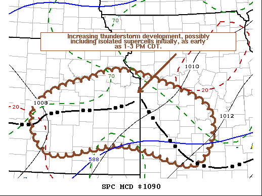
   Mesoscale Discussion 1090
   NWS Storm Prediction Center Norman OK
   1156 AM CDT Fri Jun 25 2021

   Areas affected...Much of east central into southeastern
   Kansas...southwestern/west central Missouri

   Concerning...Severe potential...Watch possible

   Valid 251656Z - 251930Z

   Probability of Watch Issuance...60 percent

   SUMMARY...Increasing thunderstorm development is expected through
   1-3 PM CDT, including potential for isolated supercells, before
   activity begins to consolidate into organizing clusters, with strong
   wind gusts becoming the more prominent potential severe weather
   hazard later this afternoon and evening.  Timing of a possible
   severe weather watch issuance remains unclear, but one probably will
   be needed by late afternoon, if not earlier.

   DISCUSSION...Beneath modestly steep lower/mid tropospheric lapse
   rates associated with a plume of warm elevated mixed-layer air, a
   moist boundary layer (including lower/mid 70s F surface dew points)
   appears characterized by large CAPE (in excess of 2500-3000 J/kg),
   south of at least a couple of remnant outflow boundaries.  One,
   south/southwest of the Lake of the Ozarks into southern portions of
   the Greater Kansas City area, remains fairly prominent, with the
   influence of precipitation still in the process of diminishing. The
   other boundary, southwest of Kansas City into areas south and west
   of Great Bend, appears more subtle, but is becoming a focus for
   stronger differential surface heating.

   Meanwhile, low amplitude/weak mid-level troughing, with smaller
   scale perturbations, is in the process of overspreading the central
   Great Plains.  This appears to have provided support for ongoing
   isolated thunderstorm development across north central Oklahoma,
   with at least attempts at new initiation northeast of Hutchinson and
   Wichita, closer to the western outflow boundary.

   While spread exists among the various model output concerning
   convective evolution, there does appear a consistent signal that a
   more substantive increase in thunderstorm development is possible as
   18-20Z.  It seems most likely that this will be focused along and
   just to the cool side of the outflow boundaries, aided by lift
   associated with warm advection, and where deep-layer shear is
   strongest beneath 25-30+ kt west-southwesterly deep layer mean
   ambient flow.  Gradually, the surface boundary intersection near/
   south of the Kansas City area may become one focus for consolidating
   thunderstorm development later this afternoon.

   Initial storm development may include isolated supercells posing a
   risk for severe hail, with perhaps some potential for a tornado,
   particularly where low-level shear appears more favorable along the
   outflow boundary south/southeast of Kansas City.  However, strong
   wind gusts associated with downbursts and strengthening surface cold
   pools will become the more prominent severe hazard as convection
   grows upscale later this afternoon.

   ..Kerr/Guyer.. 06/25/2021

   ...Please see www.spc.noaa.gov for graphic product...

   ATTN...WFO...SGF...EAX...TOP...ICT...

   LAT...LON   39309544 39189447 38419267 37249310 37689510 37449710
               38279766 38849707 39139602 39309544
|


 @NWSSPC