|
| Mesoscale Discussion 1056 |
|
< Previous MD Next MD >
|
|
Mesoscale Discussion 1056
NWS Storm Prediction Center Norman OK
0550 PM CDT Mon Jun 21 2021
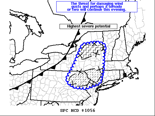
Areas affected...central and eastern New York into northeast
Pennsylvania and far northern New Jersey
Concerning...Severe Thunderstorm Watch 300...303...
Valid 212250Z - 212345Z
The severe weather threat for Severe Thunderstorm Watch 300, 303
continues.
SUMMARY...A line of severe thunderstorms with a history of severe
gusts and wind damage will likely continue to pose a risk for
damaging gusts and perhaps a tornado or two this evening. Additional
storm development/consolidation across southern New York and
northeast Pennsylvania will pose a risk for damaging winds.
DISCUSSION...Ahead of the cold front moving across western New York,
a line of thunderstorms near Syracuse has produced a measured severe
gust and numerous reports of wind damage over the last hour. Radar
data shows a well developed comma head/bowing segment developing
east of the KTYX radar. Damaging winds will be likely with this
cluster of thunderstorms as they track to the east northeast over
the next couple of hours. Regional VWP data also suggests some
mesovortex tornado threat may evolve with 0-1km SRH around 100 ms/s2
and 0-3km line normal shear around 30 kts. Some weakening of this
portions of the line may occur closer to the border with Vermont as
downstream convection has resulted in some airmass modification.
Until then, a corridor of greater severe potential will likely
evolve.
To the south across portions of northeastern Pennsylvania and
southern New York, several clusters of developing thunderstorms were
noted along a line from Binghamton to Allentown. Additional storm
development should consolidate into a linear mode with the potential
for increasing damaging wind threat as storms track through northern
New Jersey and southern New York this evening.
..Lyons.. 06/21/2021
...Please see www.spc.noaa.gov for graphic product...
ATTN...WFO...BTV...OKX...ALY...PHI...BGM...BUF...CTP...
LAT...LON 43997550 44157421 44087345 43797318 43207336 41947350
41117386 40787515 40837621 40937662 41397709 42367640
42957612 43997550
|
|
Top/All Mesoscale Discussions/Forecast Products/Home
|
|


 @NWSSPC