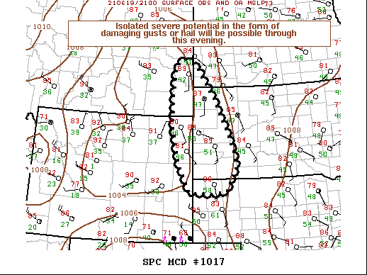
   Mesoscale Discussion 1017
   NWS Storm Prediction Center Norman OK
   0458 PM CDT Sat Jun 19 2021

   Areas affected...Southeastern Montana...northeast Wyoming...and
   portions of the Dakotas.

   Concerning...Severe potential...Watch unlikely

   Valid 192158Z - 192330Z

   Probability of Watch Issuance...20 percent

   SUMMARY...Storm initiation appears possible in the next 1 to 2 hours
   across the central and northern High Plains. A narrow corridor of
   buoyancy will support a few hours of isolated severe potential with
   high-based storms. Uncertainty on storm coverage and severity
   remains high.

   DISCUSSION...Ahead of a deepening mid-level trough observed on
   afternoon water vapor imagery, towering cumulus has become
   progressively more agitated from far southeastern Montana into
   northeastern Wyoming. Incipient updrafts along the crest of the Big
   Horns and higher terrain in southeast Montana suggests the airmass
   across the High Plains is likely nearing minimal convective
   inhibition. SPC mesoanalysis indicates between 500-1500 J/kg of
   MLCAPE have developed in a narrow corridor from the Nebraska
   Panhandle northward, owing to steep mid-level lapse rates and
   surface mixing ratios between 8 and 10 g/kg. Weak upslope flow,
   diurnal heating, and background ascent from the approaching
   mid-level wave should further diminish remaining inhibition, and may
   allow for convective development in the next couple of hours. CAM
   guidance remains unreliable in the weak ascent regime, but does hint
   at one or more clusters of storms evolving off the higher terrain
   this evening. The primary severe threats will be damaging outflow
   winds and hail, given moderate buoyancy and steep low/mid-level
   lapse rates.

   Across the Black Hills of western South Dakota, cloud debris from
   earlier convection is inhibiting strong surface heating casting
   doubt on storm initiation in this region. Here, deeper surface
   moisture and higher buoyancy may support a locally greater, but more
   conditional severe threat for wind and hail into this evening. Given
   the narrow corridor of destabilization and the uncertainty on storm
   coverage/intensity, a weather watch is unlikely, though trends will
   be monitored.

   ..Lyons/Guyer.. 06/19/2021

   ...Please see www.spc.noaa.gov for graphic product...

   ATTN...WFO...BIS...LBF...UNR...CYS...BYZ...GGW...

   LAT...LON   42540325 42570417 43430464 44650494 45680493 46490480
               46640474 46820434 46590388 45590312 44680263 43960228
               43370213 42610256 42540325
|


 @NWSSPC