|
| Mesoscale Discussion 979 |
|
< Previous MD Next MD >
|
|
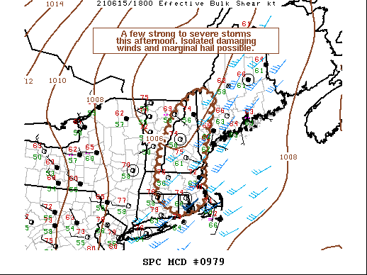
   Mesoscale Discussion 0979
   NWS Storm Prediction Center Norman OK
   0138 PM CDT Tue Jun 15 2021

   Areas affected...Portions of New England

   Concerning...Severe potential...Watch unlikely

   Valid 151838Z - 152045Z

   Probability of Watch Issuance...5 percent

   SUMMARY...A few strong to locally severe storms are possible in
   portions of southern/central New England. Damaging wind gusts will
   be the primary threat with marginally severe hail more isolated. No
   WW is expected this afternoon.

   DISCUSSION...Visible satellite and NLDN lightning trends indicate
   convection is deepening within the Connecticut River Valley. Surface
   temperatures from western Maine into eastern Massachusetts have
   risen into the mid 70s F with dewpoints holding in the upper 50s to
   low 60s F. RAP-based objective mesoanalysis suggests 500-1000 J/kg
   MLCAPE currently. Given RAP soundings are warmer at upper levels
   than regional 12Z RAOBs and surface temperatures and dewpoints are
   higher than forecast, it seems likely that MLCAPE will be skewed
   toward the higher end of the objectively analyzed range and that
   effective shear may be a touch higher given slightly deeper
   convection. The greatest storm coverage will likely occur in New
   Hampshire and western Maine where convergence is greatest within the
   surface trough. Strong heating and 35-40 kts of mid-level flow
   evident on the KBOX VWP will promote strong/damaging wind gusts. It
   is cold enough aloft that marginally severe hail could occur with
   any more organized/discrete storms.

   Farther south towards the Boston Metro, convergence in the surface
   trough is weaker and storm coverage is a bit more questionable. The
   primary forcing for convection will likely be the Atlantic sea
   breezes to the south and east. Shear is slightly greater in southern
   New England. Isolated storms would be similarly capable of damaging
   winds with marginally greater hail threat given the improved shear.

   The marginal environment will not likely support more than isolated
   severe coverage. No WW is expected.

   ..Wendt/Grams.. 06/15/2021

   ...Please see www.spc.noaa.gov for graphic product...

   ATTN...WFO...GYX...BOX...BTV...OKX...ALY...

   LAT...LON   43477257 44667197 45347101 45217030 43727070 42777083
               41917070 41477132 41497192 41987266 42667267 43477257
|
|
Top/All Mesoscale Discussions/Forecast Products/Home
|
|


 @NWSSPC