|
| Mesoscale Discussion 947 |
|
< Previous MD Next MD >
|
|
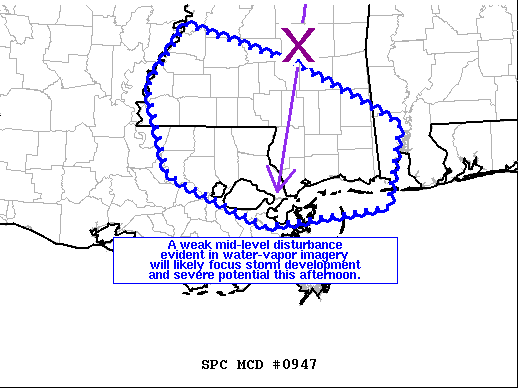
   Mesoscale Discussion 0947
   NWS Storm Prediction Center Norman OK
   1251 PM CDT Sun Jun 13 2021

   Areas affected...southern MS...southwest AL...southeast LA

   Concerning...Severe Thunderstorm Watch 265...

   Valid 131751Z - 131945Z

   The severe weather threat for Severe Thunderstorm Watch 265
   continues.

   SUMMARY...A weak mid-level disturbance evident in water-vapor
   imagery will likely focus storm development and severe potential
   across southern MS and eventually northern parts of southeast LA
   later this afternoon.

   DISCUSSION...Visible-satellite imagery shows an agitated cumulus
   field over southern MS ahead of a weak mid-level vorticity maximum
   located near Hattiesburg, MS early this afternoon.  Surface
   conditions over southern MS and northeast LA have warmed into the
   lower 90s deg F with mid to upper 70s dewpoints.  Steep surface to
   1.5 km lapse rates were noted on the 18z Jackson, MS raob with 25-30
   kt north-northeasterly flow in the 500-400 mb layer.  The
   high-PW/very unstable environment will favor water-loaded downdrafts
   with the more intense cores.  Strong to severe gusts ranging 50-70
   mph are possible with the most intense storms.  Expecting initially
   isolated storm coverage early this afternoon to further increase
   into scattered coverage by late afternoon.  The wind damage hazard
   will likely concentrate around a couple of linear clusters.

   ..Smith.. 06/13/2021

   ...Please see www.spc.noaa.gov for graphic product...

   ATTN...WFO...MOB...JAN...LIX...

   LAT...LON   29848987 30439118 31459149 32189098 31748947 31008805
               30058823 29848987
|
|
Top/All Mesoscale Discussions/Forecast Products/Home
|
|


 @NWSSPC