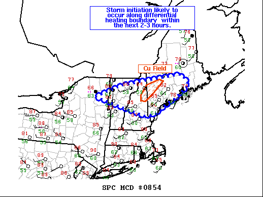
   Mesoscale Discussion 0854
   NWS Storm Prediction Center Norman OK
   0133 PM CDT Sat Jun 05 2021

   Areas affected...Portions of Northern New England

   Concerning...Severe potential...Watch possible

   Valid 051833Z - 052030Z

   Probability of Watch Issuance...40 percent

   SUMMARY...There is uncertainty in convective evolution in northern
   New England. A WW is possible this afternoon, but timing is still
   uncertain. Observational trends will continue to be monitored.

   DISCUSSION...There remains a fair amount of uncertainty as to the
   exact evolution of convection this afternoon across northern New
   England. 12Z CAM guidance presents a wide array of possible
   outcomes. Trends in surface observations and visible satellite
   depict at least two plausible scenarios. First, a band of elevated
   convection near Burlington, VT, continues to move southeastward
   producing little to no lightning. This features, in some guidance,
   is forecast to intensify as it encounters greater instability to the
   southeast near the southern Maine and New Hampshire. In those
   locations, temperatures have already risen to near 90 F with
   dewpoints currently holding in the upper 50s to low 60s F. Another
   area of potential development is likely in northern New Hampshire
   into adjacent portions of Maine along a differential heating
   boundary. There, cumulus have continued to deepen of the last hour
   and that trend should continue. Given the steep low-level lapse
   rates and moderate flow off the surface, strong/damaging wind gusts
   are the primary threat with storms this afternoon. Objectively
   analyzed 40-50 kts of effective shear will promote organized storms,
   some perhaps supercellular. Discrete storms would be capable of
   marginally severe hail and perhaps a tornado. A WW is possible this
   afternoon, though timing is uncertain. Observational trends would
   suggest development in perhaps 2-3 hours. These trends will continue
   to be monitored.

   For portions of northern Maine, uncertainty is higher given
   remaining cloud cover and cooler temperatures. The most probable
   scenario in this region is that storms will initiate somewhere in
   the St. Lawrence River vicinity and move southeastward into the
   region. This activity would more likely occur later this afternoon
   given the inhibition that is yet to be overcome.

   ..Wendt/Guyer.. 06/05/2021

   ...Please see www.spc.noaa.gov for graphic product...

   ATTN...WFO...CAR...GYX...BTV...

   LAT...LON   44147415 44697256 45066974 45146881 44686841 44096931
               43687017 43447051 43367120 44147415
|


 @NWSSPC