|
| Mesoscale Discussion 783 |
|
< Previous MD Next MD >
|
|
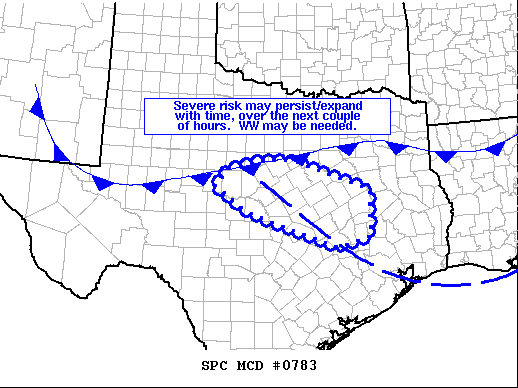
   Mesoscale Discussion 0783
   NWS Storm Prediction Center Norman OK
   1116 AM CDT Fri May 28 2021

   Areas affected...portions of central Texas

   Concerning...Severe potential...Watch possible

   Valid 281616Z - 281745Z

   Probability of Watch Issuance...60 percent

   SUMMARY...An increase in severe risk may evolve over the next 1 to 2
   hours across portions of central Texas.  WW may become necessary if
   trends persist.

   DISCUSSION...Latest radar loop shows a small cluster of
   thunderstorms that has developed in the vicinity of western Comanche
   County.  The storms appear to be developing near the intersection of
   a remnant outflow boundary -- extending southeastward into the
   Houston area -- and the synoptic front moving southward across North
   Texas.

   Steep lapse rates in place across the region are contributing to
   substantial CAPE -- which should support continued storm development
   near this boundary intersection.  While low-level flow remains a bit
   weak and disjointed, moderate mid-level westerlies will be
   sufficient to allow some updraft organization/mid-level rotation, as
   storms develop/spread east-southeastward with time.  Given the
   thermodynamics, stronger storms will be capable of producing large
   hail.  In addition, gusty winds will be possible with storms near
   and to the warm side of the surface front, and a brief tornado also
   cannot be ruled out as storms interact with the surface boundaries.

   ..Goss/Hart.. 05/28/2021

   ...Please see www.spc.noaa.gov for graphic product...

   ATTN...WFO...HGX...FWD...EWX...SJT...

   LAT...LON   32129952 32339852 32309775 31639576 30569573 30309663
               31129902 31729992 32129952
|
|
Top/All Mesoscale Discussions/Forecast Products/Home
|
|


 @NWSSPC