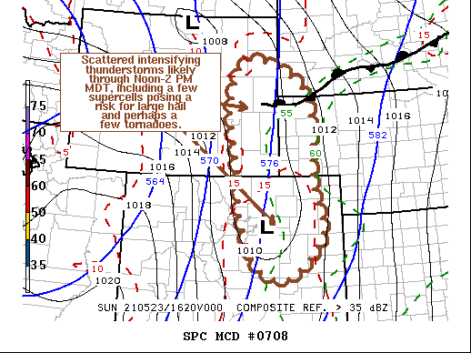
   Mesoscale Discussion 0708
   NWS Storm Prediction Center Norman OK
   1153 AM CDT Sun May 23 2021

   Areas affected...Much of eastern Wyoming and Colorado into
   southwestern South Dakota and the Nebraska Panhandle

   Concerning...Severe potential...Watch likely

   Valid 231653Z - 231900Z

   Probability of Watch Issuance...95 percent

   SUMMARY...The initiation of scattered thunderstorm development is
   expected during the next few hours, with a few supercells evolving
   through Noon-2 PM MDT.  One or more severe weather watches likely
   will be needed.

   DISCUSSION...Based on latest water vapor imagery, the leading edge
   of the stronger mid-level forcing for ascent and cooling has begun
   to overspread the Laramie Mountains, and likely will begin to spread
   into and across the Front Range between now and 18-20Z.  Coinciding
   with continuing insolation and low-level moisture advection (mid 50s
   to around 60F surface dew points across the high plains) on
   southeasterly near surface flow, steepening lapse rates appear
   likely to support moderately large CAPE in excess of 1500 J/kg, near
   and east of the higher terrain.

   As destabilization progresses, storms will initiate first across the
   higher terrain, aided by favorable orographic forcing.  However,
   within deepening surface troughing, near the Wyoming/Nebraska
   Panhandle into the plains of eastern Colorado, the initiation of at
   least widely scattered thunderstorms appears possible by 20Z.

   Southerly deep-layer ambient mean flow appears on the order of 40-45
   kt, but with flow in the 500-300 mb layer forecast to intensify to
   50-90 kt, strengthening shear will become supportive of supercells,
   with a tendency to propagate northeastward and eastward.  As storms
   propagate off the higher terrain, and form within the lee surface
   troughing, they will intensify and pose a risk for large hail and
   perhaps a couple of tornadoes by mid afternoon.

   ..Kerr/Guyer.. 05/23/2021

   ...Please see www.spc.noaa.gov for graphic product...

   ATTN...WFO...UNR...GLD...PUB...BOU...CYS...

   LAT...LON   43910499 43050311 40770293 39530267 38500374 38800477
               40010528 40500532 41560544 42800561 43910499
|


 @NWSSPC