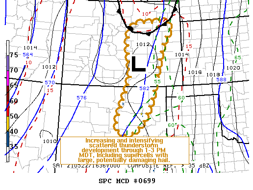
   Mesoscale Discussion 0699
   NWS Storm Prediction Center Norman OK
   1151 AM CDT Sat May 22 2021

   Areas affected...Parts of central/eastern New Mexico and Colorado

   Concerning...Severe potential...Watch likely

   Valid 221651Z - 221845Z

   Probability of Watch Issuance...80 percent

   SUMMARY...Initiation of scattered thunderstorms is underway, with a
   more substantive increase and intensification near and east of the
   Sangre de Cristo Mountains into the Front Range vicinity through 1-3
   PM MDT.  This will be accompanied by increasing risk for hail, some
   of which could become large and potentially damaging.  One or more
   severe weather watches will probably be needed.

   DISCUSSION...The elongated mid-level cold core of larger-scale
   mid/upper troughing, encompassing much of the Pacific Coast states
   into Rockies, is still over western portions of the intermountain
   region.  Only a very slow eastward progression is forecast, with the
   primary short wave impulse rounding the base of the larger-scale
   troughing only gradually pivoting across the lower Colorado Valley
   through early evening.

   However, one or two more subtle perturbations are progressing
   through the eastern periphery of larger-scale cyclonic flow, and,
   based on latest water vapor imagery, forcing for ascent with one is
   beginning to impact the Sangre de Cristo Mountains into Front Range
   vicinity.  Thunderstorms have already initiated near and north
   through southwest of the Raton Mesa vicinity, and model output
   indicates an increase in thunderstorm development is likely through
   19-21Z.

   This probably will remain largely focused close to the higher
   terrain, where moistening on southeasterly near surface flow is
   generally ongoing.  With further insolation and steepening of
   lower/mid tropospheric lapse rates, it appears that mixed-layer CAPE
   will increase in excess of 1000 J/kg, in the presence of
   strengthening deep-layer shear (40-80+ kt in the 500-300 mb layer).
   As this occurs, the environment is expected to become increasingly
   conducive to supercells capable of producing large, potentially
   damaging hail.  There may be some risk for a brief tornado, but
   model forecast soundings suggest substantive enlargement of
   low-level hodographs may not occur until much later this afternoon
   or early evening.

   ..Kerr/Guyer.. 05/22/2021

   ...Please see www.spc.noaa.gov for graphic product...

   ATTN...WFO...GLD...PUB...BOU...ABQ...

   LAT...LON   37440504 38960522 39830489 39970367 40010298 39720266
               38770322 36090399 35130458 34810542 35400577 37440504
|


 @NWSSPC