|
| Mesoscale Discussion 528 |
|
< Previous MD Next MD >
|
|
Mesoscale Discussion 0528
NWS Storm Prediction Center Norman OK
1221 PM CDT Tue May 04 2021
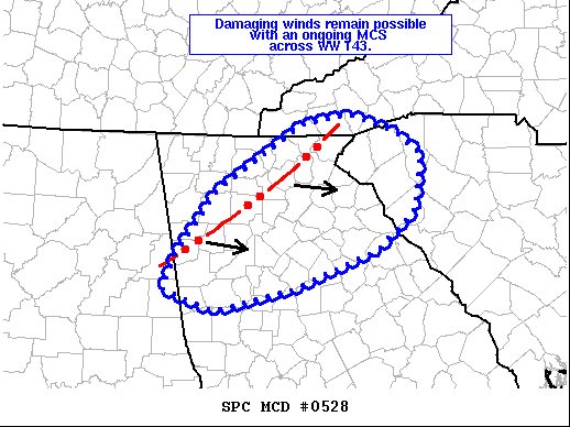
Areas affected...Northwest Georgia
Concerning...Severe Thunderstorm Watch 143...145...
Valid 041721Z - 041915Z
The severe weather threat for Severe Thunderstorm Watch 143, 145
continues.
SUMMARY...Damaging winds remain possible across northwest Georgia as
an ongoing MCS continues to move east/southeast across the region.
DISCUSSION...An ongoing MCS continues to propagate to the
east/southeast across northwest GA. Regional VWPs and RAP
mesoanalysis suggest 0-3 km bulk shear vectors are generally between
20-35 knots and are mainly aligned along the MCS's long-axis.
However, a few meridional bulges in the line have been noted in
recent KFFC imagery, which will locally enhance the potential for
damaging winds as the outflow becomes more orthogonal to somewhat
strong low-level shear vectors. This MCS should continue to
propagate to the east/southeast over the next few hours and will
continue to pose a wind threat (particularly with any north-south
oriented bulges) as MLCAPE increases across central/eastern GA amid
partly cloudy skies and boundary-layer warming. Additional
development upstream across northern AL will likely move into
northern GA in the wake of the ongoing MCS later this afternoon and
may pose an additional risk for severe winds.
..Moore.. 05/04/2021
...Please see www.spc.noaa.gov for graphic product...
ATTN...WFO...CAE...GSP...MRX...FFC...BMX...
LAT...LON 33758533 34418482 35108375 35208318 35048261 34788228
34218236 33818282 33418385 33188483 33398547 33758533
|
|
Top/All Mesoscale Discussions/Forecast Products/Home
|
|


 @NWSSPC