|
| Mesoscale Discussion 492 |
|
< Previous MD Next MD >
|
|
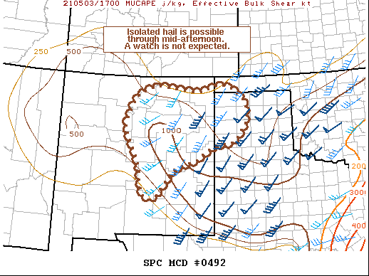
   Mesoscale Discussion 0492
   NWS Storm Prediction Center Norman OK
   1244 PM CDT Mon May 03 2021

   Areas affected...Northeast New Mexico and the Texas Panhandle

   Concerning...Severe potential...Watch unlikely

   Valid 031744Z - 031945Z

   Probability of Watch Issuance...5 percent

   SUMMARY...A few strong to severe storms are possible through
   mid-afternoon and may pose an isolated hail threat. A watch is not
   expected.

   DISCUSSION...Thunderstorms continue to develop across northeast NM
   within an upslope flow regime against the southern Rockies and
   across the western TX/OK Panhandles within a region of weak
   isentropic lift over a stalling cold frontal zone. This convection
   is being supported by elevated instability rooted above 700 mb with
   MUCAPE around 500-1000 J/kg common across the region. Strong
   upper-level flow in the vicinity of a synoptic wave over the Four
   Corners is supporting 30-45 knots of effective bulk shear, which
   will support some storm organization. Discrete to storm clusters
   appear likely and will favor a hail threat with any stronger updraft
   pulses. Storm motions northward into the cooler air mass will limit
   the severe wind potential, and storm interactions may limit storm
   longevity. The isolated, and potentially short duration, of this
   threat precludes a watch issuance, though a more robust severe
   threat is still expected to develop further south along the frontal
   boundary across west TX later this afternoon.

   ..Moore/Grams.. 05/03/2021

   ...Please see www.spc.noaa.gov for graphic product...

   ATTN...WFO...AMA...ABQ...EPZ...

   LAT...LON   34340370 34020465 33460508 33290516 33100542 33150568
               33550586 34130593 34490606 35310647 35810636 36410601
               36700527 36510366 36730282 36670239 36170180 35480183
               34930228 34800304 34340370
|
|
Top/All Mesoscale Discussions/Forecast Products/Home
|
|


 @NWSSPC