|
| Mesoscale Discussion 378 |
|
< Previous MD Next MD >
|
|
Mesoscale Discussion 0378
NWS Storm Prediction Center Norman OK
0244 PM CDT Tue Apr 13 2021
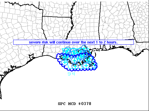
Areas affected...southern Louisiana
Concerning...Severe Thunderstorm Watch 94...
Valid 131944Z - 132145Z
The severe weather threat for Severe Thunderstorm Watch 94
continues.
SUMMARY...Severe risk continues -- mainly over coastal areas of
southern Louisiana.
DISCUSSION...Latest radar loop shows outflow from widespread inland
convection now moving southward toward/off the southern Louisiana
Coast, and is expected to clear all Parishes west of the river in
the next 1 to 2 hours. Greatest ongoing severe risk remains with
the more surface-based storms near this outflow -- across
Terrebonne/Lafourche/Jefferson/Plaquemines Parishes, where large
hail and locally strong/possibly damaging gusts may occur.
Elsewhere, weaker storms in a warm-advection regime north of the
outflow are increasing across south central Louisiana. While some
hail cannot be ruled out, the greater risk should taper off as
outflow advances into the northern Gulf of Mexico.
..Goss.. 04/13/2021
...Please see www.spc.noaa.gov for graphic product...
ATTN...WFO...LIX...LCH...
LAT...LON 29789242 29899211 29839161 29719098 29749058 29998996
29858932 29468905 28808883 28729130 29289212 29789242
|
|
Top/All Mesoscale Discussions/Forecast Products/Home
|
|


 @NWSSPC