|
| Mesoscale Discussion 371 |
|
< Previous MD Next MD >
|
|
Mesoscale Discussion 0371
NWS Storm Prediction Center Norman OK
0113 AM CDT Mon Apr 12 2021
Areas affected...Portions of the Florida Keys.
Concerning...Severe potential...Watch unlikely
Valid 120613Z - 120845Z
Probability of Watch Issuance...5 percent
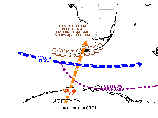
SUMMARY...Isolated severe hail is possible from convection moving
southeastward across mainly the lower/middle Keys for a few more
hours. A watch is unlikely.
DISCUSSION...Surface mesoanalysis depicts an outflow boundary --
produced by the earlier/severe peninsular MCS -- progressing
southward over the area from the central Bahamas to the Cuban
coastline near MUVR/Varadero, then northwestward across the Straits
of Florida southwest of EYW. The western part of the boundary,
northwest of Varadero, is decelerating and may stall and retreat
northward the next few hours.
VWP from BYX radar indicates the cold pool is shallow, with
southerlies at 850 mb supplying richly moist inflow to elevated
convection north of the boundary. That includes a supercell with
occasional MESH indicators of severe hail, located about 40 NNE of
EYW at 06Z, and moving southeastward generally toward the
Marathon/Seven Mile Bridge area. Other isolated strong-severe
thunderstorms also may form in this regime, where modified RAOBs and
forecast soundings suggest around 500-1000 MUCAPE atop the stable
boundary layer. Favorable vertical shear is apparent atop the cold
pool as well, in the form of veering with height and 50-60-kt
effective-shear magnitudes. The cold pool should become shallower
with time -- especially around the lower Keys -- indicating the
potential for localized downdraft gusts approaching severe limits to
penetrate to the surface as well.
..Edwards.. 04/12/2021
...Please see www.spc.noaa.gov for graphic product...
ATTN...WFO...KEY...
LAT...LON 24888070 24668100 24568159 24518212 24618294 24698291
24598211 24618180 24718169 24718158 24848149 24798125
24738118 24818091 24888070
|
|
Top/All Mesoscale Discussions/Forecast Products/Home
|
|


 @NWSSPC