|
| Mesoscale Discussion 367 |
|
< Previous MD Next MD >
|
|
Mesoscale Discussion 0367
NWS Storm Prediction Center Norman OK
1108 AM CDT Sun Apr 11 2021
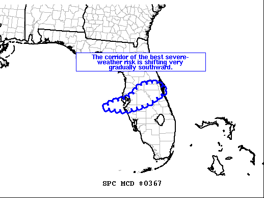
Areas affected...central Florida
Concerning...Severe Thunderstorm Watch 91...
Valid 111608Z - 111815Z
The severe weather threat for Severe Thunderstorm Watch 91
continues.
SUMMARY...Risk for locally damaging winds continues -- and is
shifting gradually southward with time.
DISCUSSION...Latest radar loop shows the initial/small bowing
cluster of storms moving eastward just to the northeast of Tampa
Bay, and is moving eastward at around 50 kt. This cluster will
affect the Orlando area, bringing gusty winds, in the next 30 to 45
minutes.
Meanwhile, a second small bowing cluster appears to be organizing
to the west-southwest along this same convective band, and should
cross the Tampa Bay area and areas just south over the next half
hour to hour. Here also, gusty winds -- possibly reaching severe
levels locally -- can be expected.
..Goss.. 04/11/2021
...Please see www.spc.noaa.gov for graphic product...
ATTN...WFO...MLB...TBW...
LAT...LON 27488382 27758342 27888280 28078231 28288216 28558188
28738098 28288048 27708140 27358260 27488382
|
|
Top/All Mesoscale Discussions/Forecast Products/Home
|
|


 @NWSSPC