|
| Mesoscale Discussion 318 |
|
< Previous MD Next MD >
|
|
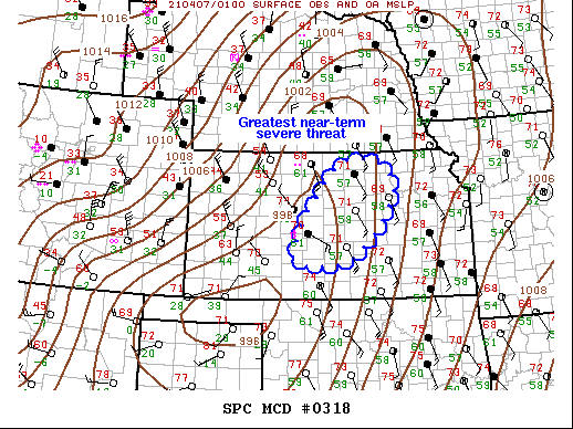
   Mesoscale Discussion 0318
   NWS Storm Prediction Center Norman OK
   0911 PM CDT Tue Apr 06 2021

   Areas affected...Central/Northern Kansas

   Concerning...Severe Thunderstorm Watch 72...

   Valid 070211Z - 070415Z

   The severe weather threat for Severe Thunderstorm Watch 72
   continues.

   SUMMARY...Greatest severe risk in the next few hours will spread
   across central/northern Kansas.

   DISCUSSION...Slow-moving thunderstorm cluster has evolved from
   Jewell-Lincoln-Stafford County KS. Leading edge of this activity is
   beginning to surge east into Ottawa County (ww73), well ahead of the
   actual cold front. While the surface front will eventually catch up
   to this developing squall line, strong LLJ focused across central KS
   will continue to provide favorable inflow for eastward propagation
   through the instability axis. Hail continues to be the primary
   concern, though gusty winds may also be noted with the bowing
   segment that is exiting the watch into Ottawa County. Southern-most
   portion of this squall line should begin to accelerate as the
   surface front will soon surge into this portion of the convective
   line.

   ..Darrow.. 04/07/2021

   ...Please see www.spc.noaa.gov for graphic product...

   ATTN...WFO...TOP...ICT...GID...DDC...

   LAT...LON   37889923 39699808 39709688 38949671 37829777 37889923
|
|
Top/All Mesoscale Discussions/Forecast Products/Home
|
|


 @NWSSPC