|
| Mesoscale Discussion 283 |
|
< Previous MD Next MD >
|
|
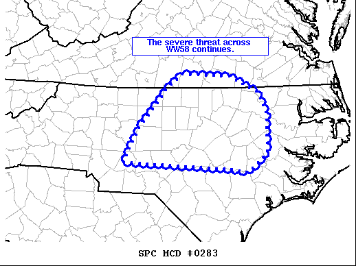
   Mesoscale Discussion 0283
   NWS Storm Prediction Center Norman OK
   0349 PM CDT Sat Mar 27 2021

   Areas affected...Central/eastern North Carolina and southern
   Virginia

   Concerning...Severe Thunderstorm Watch 58...

   Valid 272049Z - 272145Z

   The severe weather threat for Severe Thunderstorm Watch 58
   continues.

   SUMMARY...Ongoing severe storms will continue to pose a risk for
   severe winds and hail over the next couple of hours.

   DISCUSSION...Recent radar imagery and storm reports show
   strong/severe storms have continued to produce severe weather
   throughout WW58 over the last few hours. A few storms (including a
   supercell in Moore County, NC) have developed ahead of the main band
   of convection indicating the environment remains unstable and
   uninhibited. Additional storms may develop within the warm sector
   over the next few hours with a risk for damaging wind gusts and
   hail.

   Farther north into southern Virginia, storms have generally
   struggled due to a lack of buoyancy within the cooler and drier
   airmass to the north of a quasi stationary front. Severe weather
   will remain possible with the strongest cells mainly in the form of
   marginally severe hail, though the greatest severe weather risk
   across WW58 likely will remain cross North Carolina. A small
   downstream watch may be necessary as storms approach the eastern
   edge of the watch over the next 2 to 3 hours.

   ..Lyons.. 03/27/2021

   ...Please see www.spc.noaa.gov for graphic product...

   ATTN...WFO...AKQ...MHX...RAH...RNK...GSP...

   LAT...LON   36747815 36467757 36097740 35457740 35157779 35207801
               35318030 35898000 36597939 36787911 36747815
|
|
Top/All Mesoscale Discussions/Forecast Products/Home
|
|


 @NWSSPC