|
| Mesoscale Discussion 274 |
|
< Previous MD Next MD >
|
|
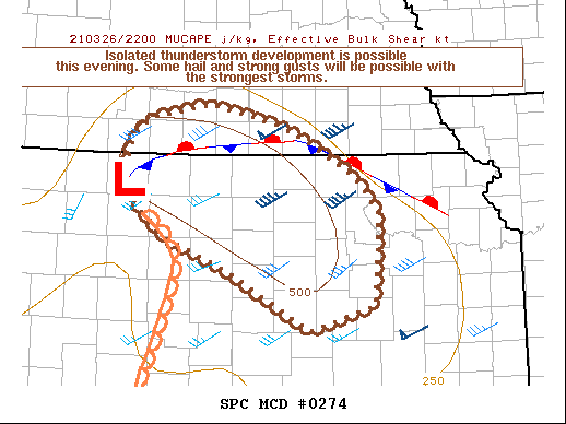
   Mesoscale Discussion 0274
   NWS Storm Prediction Center Norman OK
   0604 PM CDT Fri Mar 26 2021

   Areas affected...South-central NE into portions of northern/central
   KS

   Concerning...Severe potential...Watch unlikely

   Valid 262304Z - 270045Z

   CORRECTED FOR GEOGRAPHIC HEADLINE

   Probability of Watch Issuance...20 percent

   SUMMARY...Isolated thunderstorm development is possible this
   evening, with the strongest storms capable of posing some threat of
   hail and localized strong wind gusts.

   DISCUSSION...At 2230Z, deepening cumulus and a few nascent attempts
   at deep convection are ongoing across portions of northwest into
   central KS, near and to the east of a surface low. Low-level
   moisture remains limited across this region, but temperatures have
   warmed into the 60s F near and to the south of a warm front located
   near the NE/KS border, and isolated to widely scattered thunderstorm
   development is expected early this evening.

   The dry boundary layer in combination with a relatively low
   tropopause will result in convection that is both somewhat
   high-based and low-topped, which will tend to limit storm intensity.
   However, steep midlevel lapse rates and relatively cold temperatures
   aloft, in conjunction with effective shear of 30-40 kt, will support
   some hail threat with the strongest updrafts. Isolated strong wind
   gusts will also be possible with any storms in areas where stronger
   boundary-layer heating and mixing occurred this afternoon. The
   overall coverage and magnitude of the threat appears too limited for
   watch issuance.

   ..Dean/Grams.. 03/26/2021

   ...Please see www.spc.noaa.gov for graphic product...

   ATTN...WFO...OAX...TOP...ICT...GID...DDC...GLD...

   LAT...LON   39129935 39439975 39789996 40209983 40369961 40529881
               40329789 40159748 39779683 39399652 38449658 38179745
               38829857 39129935
|
|
Top/All Mesoscale Discussions/Forecast Products/Home
|
|


 @NWSSPC