|
| Mesoscale Discussion 270 |
|
< Previous MD Next MD >
|
|
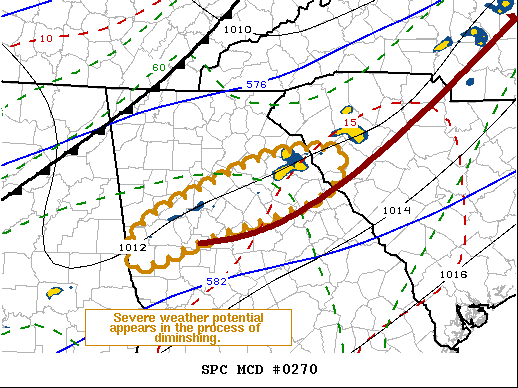
   Mesoscale Discussion 0270
   NWS Storm Prediction Center Norman OK
   0321 AM CDT Fri Mar 26 2021

   Areas affected...Parts of the Georgia into South Carolina Piedmont

   Concerning...Tornado Watch 56...

   Valid 260821Z - 260915Z

   The severe weather threat for Tornado Watch 56 continues.

   SUMMARY...The risk of severe thunderstorms may finally be in the
   process of diminishing.  If current trends continue, the remaining
   valid portion of Tornado Watch 56 may be cancelled early.

   DISCUSSION...Latest VWP data supports Rapid Refresh model forecasts
   indicating that low-level hodographs are in the process of shrinking
   and becoming more linear, along a pre-frontal low-level confluence
   zone focused near the 850 mb jet axis.  Across the Georgia into
   South Carolina Piedmont, speeds along this axis are beginning to
   weaken, as the main short wave trough of influence continues into
   the Great Lakes region.  As this occurs, forcing for ascent along
   this zone is also weakening, and convective intensities are
   following suit.  Severe weather potential across the Greater Atlanta
   metro area appears to have diminished, and similar trends are
   underway east-northeastward through the remainder of the watch area.

   ..Kerr.. 03/26/2021

   ...Please see www.spc.noaa.gov for graphic product...

   ATTN...WFO...CAE...GSP...FFC...

   LAT...LON   34288303 34258233 33778271 33348411 32978510 33468500
               34098370 34288303
|
|
Top/All Mesoscale Discussions/Forecast Products/Home
|
|


 @NWSSPC