|
| Mesoscale Discussion 204 |
|
< Previous MD Next MD >
|
|
Mesoscale Discussion 0204
NWS Storm Prediction Center Norman OK
0101 PM CDT Wed Mar 17 2021
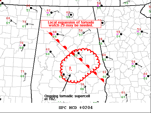
Areas affected...portions of central Alabama
Concerning...Tornado Watch 29...
Valid 171801Z - 171930Z
The severe weather threat for Tornado Watch 29 continues.
SUMMARY...A local expansion of tornado watch 29 may be needed.
DISCUSSION...A favorable tornadic environment exists across central
Alabama with temperatures in the mid 70s and dewpoints in the upper
60s yielding MLCAPE around 1000 to 1500 J/kg. In addition, this area
is in close proximity to the warm front where low-level winds are
backed and low-level SRH is maximized. A supercell which developed
in Dallas County has taken advantage of this favorable tornadic
environment with radar evidence of a tornado near the Dallas Autauga
county line. There is considerable question regarding the longevity
of the tornado threat with this activity. The warm sector is
advecting northeastward, but this storm may eventually move to the
cool side of the boundary. However, given the potential for this
storm to potentially move out of watch 29 and additional shower
development to it's south and southeast which could deepen and
become tornadic, watch 29 may need to be expanded into eastern
Alabama.
..Bentley/Grams.. 03/17/2021
...Please see www.spc.noaa.gov for graphic product...
ATTN...WFO...BMX...
LAT...LON 32798706 33238651 33308594 33088554 32718535 32368592
32078630 32128689 32358707 32798706
|
|
Top/All Mesoscale Discussions/Forecast Products/Home
|
|


 @NWSSPC