|
| Mesoscale Discussion 197 |
|
< Previous MD Next MD >
|
|
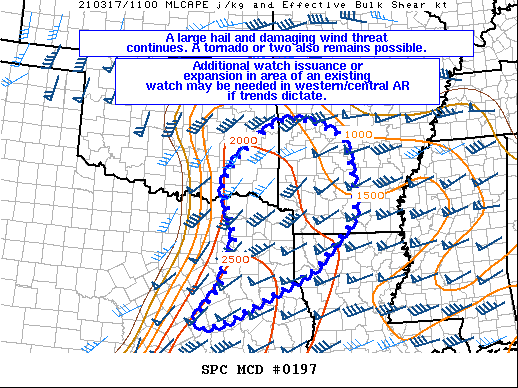
   Mesoscale Discussion 0197
   NWS Storm Prediction Center Norman OK
   0640 AM CDT Wed Mar 17 2021

   Areas affected...Portions of east/northeast TX...eastern
   OK...western/central AR...and far northwestern LA

   Concerning...Severe Thunderstorm Watch 25...

   Valid 171140Z - 171315Z

   The severe weather threat for Severe Thunderstorm Watch 25
   continues.

   SUMMARY...A large hail and damaging wind threat continues across
   Severe Thunderstorm Watch 25. A tornado or two also remains
   possible. Additional watch issuance or expansion of an existing
   watch may be needed in western/central Arkansas as storms approach
   this region.

   DISCUSSION...A squall line has developed east of the Metroplex in
   east-central/northeast TX. Multiple measured wind gusts of 61-73 mph
   were reported with this line, along with 1-1.25" diameter hail. A
   moderately to strongly unstable airmass (MLCAPE 1500-2500 J/kg)
   exists to the east of the ongoing convection in northeast TX and
   vicinity. Severe/damaging wind gusts should continue to be the main
   threat in the short term given the primarily linear mode and strong
   low to mid-level flow present. Isolated, marginally severe hail also
   appears possible, but this should be a secondary threat compared to
   the severe wind potential. The tornado threat across the ArkLaTex
   vicinity should increase later this morning as the boundary layer
   destabilizes, and the low/mid-level flow remains quite favorable for
   updraft rotation. Still, in the short term, the tornado threat may
   be somewhat limited by the linear storm mode. Additional convection
   along the OK/AR border has recently developed along an
   outflow/bore-like feature. This activity may also pose an isolated
   large hail and damaging wind threat if it can strengthen further. At
   this point, the need for an additional watch or expansion in area of
   an existing watch into western/central AR is unclear, but trends
   will be closely monitored.

   ..Gleason.. 03/17/2021

   ...Please see www.spc.noaa.gov for graphic product...

   ATTN...WFO...LZK...SHV...TSA...HGX...FWD...OUN...

   LAT...LON   31099658 31839595 32939559 34189597 34719557 35409474
               35619431 35589357 35199268 34229242 33369242 32239350
               31089578 30919634 31099658
|
|
Top/All Mesoscale Discussions/Forecast Products/Home
|
|


 @NWSSPC