|
| Mesoscale Discussion 174 |
|
< Previous MD Next MD >
|
|
Mesoscale Discussion 0174
NWS Storm Prediction Center Norman OK
0355 AM CDT Sun Mar 14 2021
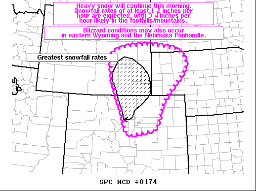
Areas affected...Portions of north-central/northeastern CO into
southeastern WY...the NE Panhandle...and far southwestern SD
Concerning...Heavy snow
Valid 140855Z - 141500Z
SUMMARY...Heavy snow will continue this morning. Snowfall rates of
at least 1-2 inches per hour are expected, with 3-4 inches per hour
likely in the foothills/mountains. Blizzard conditions may also
occur in eastern Wyoming and the Nebraska Panhandle.
DISCUSSION...A deep, closed upper low will continue moving slowly
eastward over the southern/central Rockies and adjacent High Plains
this morning. Strong low to mid-level easterly upslope flow will
persist across much of the Front Range of northern CO and the
Laramie Mountains in southeastern WY. An ongoing band of moderate to
heavy snow is expected to continue this morning across much of
north-central into northeastern CO and southeastern WY. Strong
ascent associated with a mid/upper-level jet through a deep,
saturated dendritic growth zone will foster widespread 1-2 inch per
hour snowfall rates within the band. Terrain enhancement owing to
the pronounced low-level upslope flow will likely support even
higher snowfall rates of 3-4 inches per hour along the foothills and
into the mountains. This heavy snow is expected to continue through
the morning owing to the slow-moving nature of the overall cyclone,
while gradually spreading northward into more of eastern WY, the NE
Panhandle, and eventually southwestern SD. Greatly reduced
visibilities and potential blizzard conditions owing to blowing snow
also appear possible across southeastern WY and the western NE
Panhandle this morning, as the surface pressure gradient should be
greatest over these areas. Latest guidance suggests that the highest
snowfall rates through 15Z will focus along the Front Range north of
Denver towards the Medicine Bow Mountains, Laramie Mountains, and
Cheyenne.
..Gleason.. 03/14/2021
...Please see www.spc.noaa.gov for graphic product...
ATTN...WFO...LBF...UNR...BOU...CYS...RIW...
LAT...LON 41850225 41240289 40690336 40130360 39810365 39440392
39220523 39410556 40040573 40910609 41760642 42570653
43020638 43240554 43360446 43280354 43110245 42710192
42180193 41850225
|
|
Top/All Mesoscale Discussions/Forecast Products/Home
|
|


 @NWSSPC