|
| Mesoscale Discussion 132 |
|
< Previous MD Next MD >
|
|
Mesoscale Discussion 0132
NWS Storm Prediction Center Norman OK
0606 PM CST Sat Feb 27 2021
Areas affected...Tennessee Valley
Concerning...Severe potential...Watch unlikely
Valid 280006Z - 280230Z
Probability of Watch Issuance...20 percent
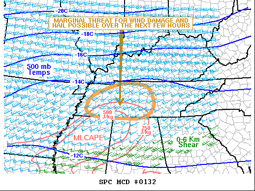
SUMMARY...A threat for strong wind gusts and hail is expected across
parts of western and middle Tennessee over the next few hours. Due
to the marginal nature of the threat, weather watch issuance is not
expected.
DISCUSSION...The latest surface analysis shows a quasi-stationary
front located from far northern Mississippi extending
east-northeastward across southern Tennessee. A corridor of
maximized low-level moisture is analyzed to the south of the front
where surface dewpoints are in the lower to mid 60s F. According to
the RAP, MLCAPE has increased into the 250 to 750 J/kg range along
this tongue of low-level moisture. Thunderstorms have recently
developed into western Tennessee along the northern edge of the
instability corridor. The storms are being supported by a warm
advection regime. The storms should continue to spread
east-northeastward across middle Tennessee over the next few hours.
The weak instability combined with 60-65 kt of deep-layer shear,
evident on the Nashville WSR-88D VWP will support a marginal wind
damage and hail threat. However, the threat is not expected to be
sufficient to warrant weather watch issuance.
..Broyles/Grams.. 02/28/2021
...Please see www.spc.noaa.gov for graphic product...
ATTN...WFO...OHX...HUN...MEG...
LAT...LON 34958763 34998881 35138935 35368956 35798939 36128888
36528757 36478644 36188595 35478583 35008642 34958763
|
|
Top/All Mesoscale Discussions/Forecast Products/Home
|
|


 @NWSSPC