|
| Mesoscale Discussion 63 |
|
< Previous MD Next MD >
|
|
Mesoscale Discussion 0063
NWS Storm Prediction Center Norman OK
0324 AM CST Sun Feb 07 2021
Areas affected...Virginia...Southeast West Virginia
Concerning...Heavy snow
Valid 070924Z - 071530Z
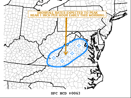
SUMMARY...Moderate to heavy snow is expected to develop from
southeast West Virginia into western, central and northern Virginia
early this morning. Snowfall rates of 1 inch per hour will be
possible.
DISCUSSION...The latest mosaic radar imagery shows a large area of
precipitation from the central Appalachians eastward to the
Mid-Atlantic. At this time, temperatures are below freezing at the
higher elevations across the central Appalachian Mountains, where
heavy snow was reported last hour in southeastern West Virginia.
This band of snow is forming ahead of a shortwave trough evident on
water vapor imagery. As the shortwave trough moves northeastward
across the central Appalachians early this morning, isentropic
ascent will increase markedly across much of western and central
Virginia. In response, moderate to heavy snow is forecast to develop
with the band across western and central Virginia. The band will
develop northeastward with time, reaching northern Virginia toward
daybreak. Snowfall rates are expected to peak near 1 inch per hour
in the heaviest part of the band. Snow accumulation rates will not
be maximized in areas where surface temperatures remain slightly
above freezing. The potential for this limitation appears greatest
across parts of east-central and northeast Virginia.
..Broyles.. 02/07/2021
...Please see www.spc.noaa.gov for graphic product...
ATTN...WFO...AKQ...LWX...RNK...RLX...
LAT...LON 36758145 37198147 37738115 38238006 38697904 38977836
39017761 38717711 38307704 37847737 37217850 36627966
36568085 36758145
|
|
Top/All Mesoscale Discussions/Forecast Products/Home
|
|


 @NWSSPC