|
| Mesoscale Discussion 46 |
|
< Previous MD Next MD >
|
|
Mesoscale Discussion 0046
NWS Storm Prediction Center Norman OK
0501 PM CST Sat Jan 30 2021
Areas affected...far southwest MO
Concerning...Severe potential...Watch unlikely
Valid 302301Z - 310000Z
Probability of Watch Issuance...20 percent
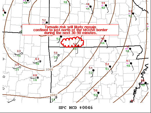
SUMMARY...A tornado risk will likely remain confined to developing
warm-sector supercells in far southwest MO during the next 30-90
minutes.
DISCUSSION...Latest surface mesoanalysis indicates surface flow has
backed from south-southwesterly to southerly in Stone County per an
observation site. Equally important, surface conditions show a
temperature and dewpoint at 55 deg F. The cold pocket aloft
associated with the migratory mid-level shortwave trough has
resulted in 500 mb temperatures around -22.5 deg C. In summary,
adequate buoyancy 500 J/kg MLCAPE is co-located with strong
low-level shear. RAP forecast soundings estimate around 225 m2/s2
0-500m SRH. Given this seemingly focused thermodynamic/kinematic
environment, it seems plausible any supercell with a relatively
undisturbed inflow to the south will be capable of cyclic
mesocyclones with an accompanying threat for a weak tornado or two.
..Smith.. 01/30/2021
...Please see www.spc.noaa.gov for graphic product...
ATTN...WFO...SGF...
LAT...LON 36749393 36849312 36699295 36599291 36559387 36749393
|
|
Top/All Mesoscale Discussions/Forecast Products/Home
|
|


 @NWSSPC