|
| Mesoscale Discussion 33 |
|
< Previous MD Next MD >
|
|
Mesoscale Discussion 0033
NWS Storm Prediction Center Norman OK
0449 PM CST Mon Jan 25 2021
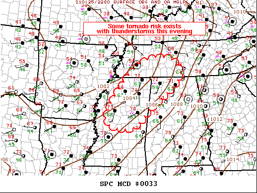
Areas affected...Northern/Central Mississippi...Western/Middle
Tennessee...Northwest Alabama
Concerning...Severe potential...Watch possible
Valid 252249Z - 260015Z
Probability of Watch Issuance...60 percent
SUMMARY...Scattered strong thunderstorms are expected across the
Mid-South into Middle TN this evening. Some risk for tornadoes may
necessitate a watch in the next couple of hours.
DISCUSSION...Strong mid-level short-wave trough is ejecting across
the central Plains this evening. The more appreciable height falls
will spread across the Mid-MS into the OH Valley region. Along the
southern fringe of this stronger large-scale forcing, robust
convection has recently developed across portions of western TN
where surface dew points have risen into the mid 60s with surface
temperatures in the lower 70s. This activity should spread
east-northeast along a corridor that is destabilizing just south of
a well-defined warm front. Ample shear/buoyancy exist for supercells
(possibly tornadic supercell ongoing over Fayette County TN) and
there is increasing concern/confidence that other organized
longer-lived storms may develop.
Farther south along the Pacific front, showers are gradually
deepening from northwest MS into northeast LA. Some lightning is
noted with the stronger updrafts but activity has struggled to
organize. It's not entirely clear how many organized supercells
can/will develop along this zone, but shear/buoyancy do favor some
tornado threat. Tornado watch may be warranted for this activity in
the next couple of hours.
..Darrow/Thompson.. 01/25/2021
...Please see www.spc.noaa.gov for graphic product...
ATTN...WFO...OHX...BMX...HUN...MEG...JAN...
LAT...LON 33159055 35478893 35888710 35008651 33568819 32718919
33159055
|
|
Top/All Mesoscale Discussions/Forecast Products/Home
|
|


 @NWSSPC