|
| Mesoscale Discussion 2039 |
|
< Previous MD Next MD >
|
|
Mesoscale Discussion 2039
NWS Storm Prediction Center Norman OK
0551 PM CDT Sun Sep 29 2019
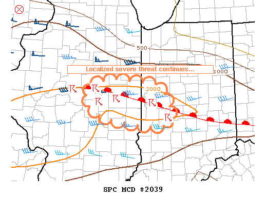
Areas affected...east-central Illinois and west-central Indiana
Concerning...Severe potential...Watch unlikely
Valid 292251Z - 292345Z
Probability of Watch Issuance...20 percent
SUMMARY...A localized severe threat continues along a warm front in
the region. Hail, damaging wind gusts, and an isolated tornado are
the main threats. A WW issuance is not anticipated for this
activity.
DISCUSSION...Lift associated with a mid-level shortwave trough
centered over eastern Iowa and weak to moderate instability along a
surface warm front has resulted in a cluster of multicell/supercell
storms. One of these storms has exhibited strong, yet brief,
low-level rotation as it traversed the warm front near Mason County,
Illinois. These storms continue on their eastern trek in the
vicinity of the warm front and continue with mid-level rotation and
signatures consistent with large hail.
The downstream airmass suggests that this focused, yet isolated
severe threat should continue with eastward extent and potentially
reach west-central Indiana through sunset. Thereafter, boundary
layer cooling should result in a lessened severe risk. The brief
and localized window for this severe risk should preclude a WW
issuance.
..Cook/Guyer.. 09/29/2019
...Please see www.spc.noaa.gov for graphic product...
ATTN...WFO...IND...LOT...ILX...
LAT...LON 40408710 40528837 40368908 39968912 39648859 39468743
39488671 39728661 40118677 40408710
|
|
Top/All Mesoscale Discussions/Forecast Products/Home
|
|


 @NWSSPC