Mesoscale Discussion 1953
NWS Storm Prediction Center Norman OK
1131 PM CDT Tue Sep 10 2019
Areas affected...Parts of southeastern South Dakota...southwestern
Minnesota...northeastern Nebraska...northwestern Iowa
Concerning...Severe Thunderstorm Watch 643...
Valid 110431Z - 110600Z
The severe weather threat for Severe Thunderstorm Watch 643
continues.
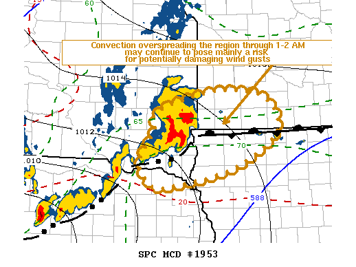
SUMMARY...An evolving cluster of storms may continue to pose a risk
for strong surface gusts east of Sioux Falls SD, near the western
Minnesota/Iowa border area through 1-2 AM CDT. It is not certain
that a new severe weather watch will be needed farther east, but
trends will continue to be monitored for this possibility.
DISCUSSION...Vigorous thunderstorm development persists, southeast
and south of a lower/mid tropospheric cyclonic vorticity center
which has become increasingly evident in radar imagery, currently
east of Mitchell SD. This is also near the nose of a strengthening
and gradually veering southerly low-level jet (40-50 kt at 850 mb),
but generally to the cool side of the effective warm frontal zone
(across southeastern South Dakota) and a southeastward advancing
outflow boundary (across north central Nebraska).
Low-level shear is strong ahead of the convective outflow across
southeastern South Dakota, where modest near surface easterlies veer
to southerly and southwesterly aloft. However, north of the surface
front, near surface thermodynamic profiles are cool and stable to
surface-based convection. The risk for tornadoes appears low, but
the environment may be conducive to strong surface gusts as activity
spreads east of the Sioux Falls area, near the western
Minnesota/Iowa border area through 06-07Z.
This leading convection has been advancing eastward roughly with the
modest 20-30 kt westerly deep-layer ambient mean flow, but some
eastward acceleration is possible during the next couple of hours.
..Kerr.. 09/11/2019
...Please see www.spc.noaa.gov for graphic product...
ATTN...WFO...MPX...DMX...FSD...OAX...
LAT...LON 44089630 44149577 44019490 43469464 42879561 42609687
42569745 42949775 43469742 43799736 44089630
|


 @NWSSPC