|
| Mesoscale Discussion 1927 |
|
< Previous MD Next MD >
|
|
Mesoscale Discussion 1927
NWS Storm Prediction Center Norman OK
0500 AM CDT Thu Sep 05 2019
Areas affected...NC Cape Fear vicinity
Concerning...Tornado Watch 635...
Valid 051000Z - 051100Z
The severe weather threat for Tornado Watch 635 continues.
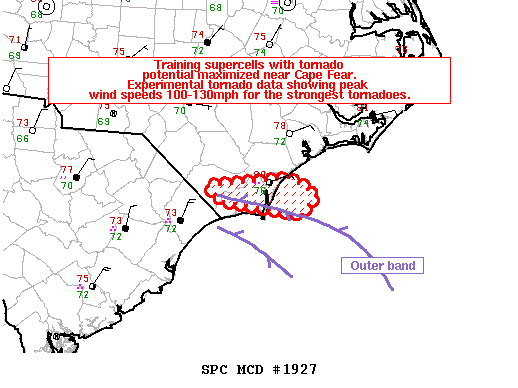
SUMMARY...Training supercells with tornado potential maximized near
and north of Cape Fear for the next hour. Experimental tornado data
showing peak wind speeds 100-130mph range for the strongest
tornadoes.
DISCUSSION...Radar mosaic shows two outer bands on the northern
envelope of Hurricane Dorian located near the border of the SC/NC
coast. The maritime warm front has infiltrated the immediate
coastal counties with observed surface conditions showing
temperatures in the upper 70s to near 80 degrees F and middle-upper
70s dewpoints. This is resulting in around 1000 J/kg MLCAPE per RAP
forecast soundings. Additionally, the KLTX VAD is showing around
300 m2/s^2 0-1km SRH when accounting for observed storm motion. A
recently tornadic circulation (TDS signature) over Brunswick County,
NC likely possessed peak wind speeds between 100-130mph according to
experimental tornado data. It seems plausible additional supercell
tornadoes will probably develop or move onshore during the next 1-2
hours as the outer band gradually shifts slowly north.
..Smith.. 09/05/2019
...Please see www.spc.noaa.gov for graphic product...
ATTN...WFO...ILM...
LAT...LON 34237874 34337761 34127726 33897747 34057857 34237874
|
|
Top/All Mesoscale Discussions/Forecast Products/Home
|
|


 @NWSSPC