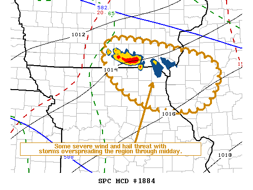
   Mesoscale Discussion 1884
   NWS Storm Prediction Center Norman OK
   1055 AM CDT Thu Aug 29 2019

   Areas affected...Parts of southeast Iowa...northeast Missouri and
   adjacent west central Illinois

   Concerning...Severe potential...Watch unlikely

   Valid 291555Z - 291730Z

   Probability of Watch Issuance...20 percent

   SUMMARY...Strong storms may pose at least some risk for severe hail
   and strong surface gusts into midday, before diminishing.  Due to
   the expected marginal and short-lived nature of this threat, a
   severe weather watch is not anticipated, but trends will be
   monitored.

   DISCUSSION...A sustained area of thunderstorm development has been
   spreading east-southeastward across southern Iowa, likely primarily
   supported and rooted within an area of forcing for ascent associated
   with warm advection accompanying a 30-35 kt west-northwesterly 850
   mb jet.  Inflow of air originating from the moist and warming
   boundary layer over the mid Missouri Valley probably has contributed
   to recent intensification near the northern Missouri state border,
   southwest of Ottumwa IA.  In the presence of strong deep-layer shear
   within the convective layer, inflow CAPE may now be in excess of
   2000 J/kg, contributing to convection capable of producing severe
   hail.

   Some risk for strong surface gusts could eventually develop as
   activity continues to develop east-southeastward through midday.
   However, models suggest that the supporting forcing/low-level jet
   will gradually weaken while shifting across the remainder of
   southern Iowa into central Illinois.  Current convective intensities
   and associated severe weather potential may be fairly short-lived.
   Some destabilization of the boundary layer is occurring to the south
   of the ongoing storm cluster, across northern Missouri into central
   Illinois, in response to insolation and low-level moisture
   advection.  However, although not out of the question, it currently
   appears unlikely to destabilize rapidly enough to allow for
   convection to begin to take root within the boundary layer, along
   the developing cold pool, before the ongoing "elevated" activity
   begins to dissipate.

   ..Kerr/Thompson.. 08/29/2019

   ...Please see www.spc.noaa.gov for graphic product...

   ATTN...WFO...ILX...LSX...DVN...DMX...EAX...

   LAT...LON   41219319 41039138 40588996 39689042 39719201 40429317
               41219319
|


 @NWSSPC