|
| Mesoscale Discussion 1557 |
|
< Previous MD Next MD >
|
|
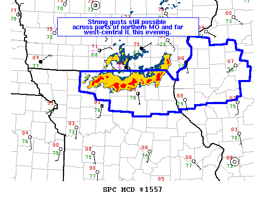
   Mesoscale Discussion 1557
   NWS Storm Prediction Center Norman OK
   0853 PM CDT Sat Jul 20 2019

   Areas affected...portions of northern MO into west-central IL

   Concerning...Severe Thunderstorm Watch 535...

   Valid 210153Z - 210300Z

   The severe weather threat for Severe Thunderstorm Watch 535
   continues.

   SUMMARY...Sporadic strong wind gusts are still possible, mainly
   across parts of northern MO through the remainder of the evening.

   DISCUSSION...A line of strong storms continues to shift south this
   evening into portions of north-central and northeast MO. Additional
   isolated storms may also clip parts of far west-central IL. Measured
   severe gusts greater than 60 mph occurred earlier this evening
   across southern IA with additional wind damage reports received near
   the MO/IA border in the last hour or so.  Overall intensity appears
   to have waned some recently as convection shifts south of better
   deep layer flow. KIRK reported a 37 kt gust at 0139Z. Strong
   instability remains downstream, with surface dewpoints in the mid
   70s contributing to 3000+ J/kg MLCAPE. Weak low level flow, steep
   lapse rates and high PW values will continue to support strong
   downdrafts and locally severe wind gusts are possible over the next
   couple of hours.

   Overall the threat should diminish over the next few hours.
   Furthermore, the threat across west-central IL likely will not
   develop as far east as previously expected and portions of the watch
   could be cancelled early.

   ..Leitman.. 07/21/2019

   ...Please see www.spc.noaa.gov for graphic product...

   ATTN...WFO...GYX...BOX...OKX...ALY...BGM...

   LAT...LON   42737489 43047421 42987316 42727173 42417113 42077122
               41787141 41587209 41527313 41607405 42017474 42447491
               42737489
|
|
Top/All Mesoscale Discussions/Forecast Products/Home
|
|


 @NWSSPC