|
| Mesoscale Discussion 1443 |
|
< Previous MD Next MD >
|
|
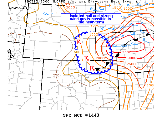
   Mesoscale Discussion 1443
   NWS Storm Prediction Center Norman OK
   0326 PM CDT Fri Jul 12 2019

   Areas affected...southeast WY...far northeast CO and the NE
   Panhandle

   Concerning...Severe potential...Watch unlikely

   Valid 122026Z - 122200Z

   Probability of Watch Issuance...20 percent

   SUMMARY...Isolated storms could produce hail and locally strong wind
   gusts over the next few hours.

   DISCUSSION...Thunderstorms have developed in easterly upslope flow
   regime over higher terrain this afternoon. A quasi-stationary
   surface boundary extended east/northeast from a surface low over
   northeast CO into north-central NE, with a surface trough extending
   north to south across eastern WY. This is resulting in confluent
   flow over the region from far northeast CO into southeast WY and
   western NE, where dewpoints ranged from the low 60s west to low 70s
   east, except near higher terrain where dewpoints were in the 50s.
   Atop this moist airmass, very steep lapse rates are in place atop a
   weakening EML, and the boundary layer becomes increasingly unstable
   with eastward extent into the richer boundary layer moisture. MLCAPE
   quickly increases from around 1000 J/kg near I-25 to great than 2000
   J/kg across western NE. As storms move off of higher terrain into
   this reservoir of instability, modest effective shear (25-35 kt)
   should be sufficient to maintain brief strong updrafts and organized
   cells, the strongest of which will be capable of hail and locally
   strong wind gusts. This initial threat should remain rather isolated
   over the next 1-3 hours and a watch is not immediately necessary.
   However, a greater threat could develop downstream across parts of
   northern/central NE later this evening/tonight if organized
   convection can develop/persist. This threat may need to be addressed
   separately in the coming hours.

   ..Leitman/Grams.. 07/12/2019

   ...Please see www.spc.noaa.gov for graphic product...

   ATTN...WFO...LBF...BOU...CYS...

   LAT...LON   41260570 41860587 42490593 42820566 42970500 42920391
               42510309 41840267 40730257 40390288 40220343 40160418
               40260474 40530545 41260570
|
|
Top/All Mesoscale Discussions/Forecast Products/Home
|
|


 @NWSSPC